Hoyt–Schermerhorn Streets (New York City Subway)
| Hoyt–Schermerhorn Streets | |||||||||||
|---|---|---|---|---|---|---|---|---|---|---|---|
| New York City Subway rapid transit station | |||||||||||
|
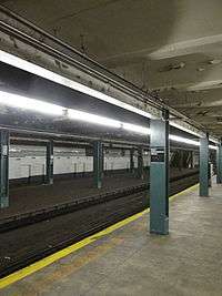
Queens-bound platform | |||||||||||
| Station statistics | |||||||||||
| Address |
Hoyt Street & Schermerhorn Street Brooklyn, NY 11201 | ||||||||||
| Borough | Brooklyn | ||||||||||
| Locale | Downtown Brooklyn | ||||||||||
| Coordinates | 40°41′20.48″N 73°59′10.11″W / 40.6890222°N 73.9861417°WCoordinates: 40°41′20.48″N 73°59′10.11″W / 40.6890222°N 73.9861417°W | ||||||||||
| Division | B (IND) | ||||||||||
| Line |
IND Crosstown Line IND Fulton Street Line | ||||||||||
| Services |
A C G | ||||||||||
| Transit connections |
| ||||||||||
| Structure | Underground | ||||||||||
| Platforms |
4 island platforms (2 in passenger service) cross-platform interchange | ||||||||||
| Tracks | 6 (4 in passenger service) | ||||||||||
| Other information | |||||||||||
| Opened | April 9, 1936[1] | ||||||||||
| Accessibility | Cross-platform wheelchair transfer available | ||||||||||
| Traffic | |||||||||||
| Passengers (2015) |
3,038,302[2] | ||||||||||
| Rank | 171 out of 422 | ||||||||||
| Station succession | |||||||||||
| Next north |
Jay Street – MetroTech (Fulton express): A Court Street (Fulton local): no regular service Fulton Street (Crosstown): G | ||||||||||
| Next south |
Lafayette Avenue (Fulton local): A Nostrand Avenue (Fulton express): A Bergen Street (Culver): G | ||||||||||
| |||||||||||
| |||||||||||


Hoyt–Schermerhorn Streets is an express station of the New York City Subway, serving the IND Crosstown Line and the IND Fulton Street Line. Located at the intersection of Hoyt Street and Schermerhorn Street in Downtown Brooklyn, it is served by the:
History
Hoyt–Schermerhorn Streets was constructed as a junction between the Fulton Street and Crosstown lines of the Independent Subway System (IND), and part of the section of the Fulton Street subway under Schermerhorn Street between Court Street and Bond Street.[3][4][5] Surveying by the New York City Board of Transportation along Schermerhorn Street began in 1928,[6][7][8] and construction began around 1929.[3][4] Property on the south side of Schermerhorn Street between Bond and Nevins Streets was condemned to facilitate the project.[9][10] Like other stations along the lines, it was constructed via shallow cut-and-cover methods, with the street covered by wooden planks.[11] In September 1929, a portion of the "plank road" above the station site collapsed.[12][13]
The station was ceremonially opened by Mayor Fiorello LaGuardia on April 9, 1936, with the station serving both Fulton Street Line local and express trains.[1][14] The station cost approximately $3 million to construct, with the tilework costing $131,000.[14] This station began serving Crosstown Line trains on July 1, 1937, when the Crosstown Line was extended from Nassau Avenue.[15] From this station, northbound Fulton local trains were planned to continue to Court Street and terminate there. Express trains would turn north under Jay Street and continue to Manhattan via the Cranberry Street Tunnel. However, initial Fulton Street service ran entirely local at the time, as the line only ran to Rockaway Avenue. Without express service, local trains provided service to Manhattan via the express tracks at this station while the HH shuttle was instituted to serve Court Street and the local tracks/platforms.[14][16][17]
On October 9, 1936, a public hearing was held to discuss the construction of a passageway between the station and the Loeser's Department Store.[18] In November 1937, the city Board of Transportation approved the construction of a 250-foot (76 m) passageway between the station and the department store.[19] Due to low ridership, the Court Street station was closed and the shuttle was discontinued in 1946.[20][21] All Fulton Street service was routed via the express tracks at this station to Jay Street – Borough Hall. This eliminated any use for the local tracks and they have been out of service since. The outer platforms were also closed until 1959, when the Aqueduct Racetrack special service began.[22] Service ran from the lower level of 42nd Street – Port Authority Bus Terminal to Aqueduct Racetrack via the IND Eighth Avenue Line, Fulton Street Line, and IND Rockaway Line.[22] Like the lower level at 42nd Street, the outer platforms at this station provided a convenient place to segregate passengers who had paid the extra fare required to board the special trains. Consequently, Hoyt–Schermerhorn Streets was the only stop between 42nd Street and the racetrack.[22]
Since the elimination of the Aqueduct service in 1981,[11] the outer platforms have remained out of revenue service. The abandoned parts of the station are used occasionally for film shoots[11][23]—for example, The Warriors and The Taking of Pelham 123[11]—and other special functions, such as a public display of the R160Bs on November 29, 2005.[24]
Following the 2009 death of Michael Jackson, New York City Council member Letitia James advocated renaming the station in Jackson's honor and hanging a plaque at the station to commemorate the filming of the video for "Bad" there. However, James's proposal was met with resistance from the Metropolitan Transportation Authority.[25][26] MTA spokesperson Kevin Ortiz explained that the agency is currently developing guidelines for station naming-rights deals in order to raise money. In addition, naming stations after individuals could confuse riders who are traveling to a specific location or street near Hoyt–Schermerhorn.[25][26] The MTA also declined to put a plaque in the station, due to MTA guidelines banning such an action.[26][27]
Station layout
Track layout | ||||||||||||||||||||||||||||||||||||||||||||||||||||||||||||||||||||||||||||||||||||||||||||||||||||||||||||||||||||||||||||||||||||||||||||||||||||||||||||||||||||||||||||||||||||||||||||||||||||||||||||
|---|---|---|---|---|---|---|---|---|---|---|---|---|---|---|---|---|---|---|---|---|---|---|---|---|---|---|---|---|---|---|---|---|---|---|---|---|---|---|---|---|---|---|---|---|---|---|---|---|---|---|---|---|---|---|---|---|---|---|---|---|---|---|---|---|---|---|---|---|---|---|---|---|---|---|---|---|---|---|---|---|---|---|---|---|---|---|---|---|---|---|---|---|---|---|---|---|---|---|---|---|---|---|---|---|---|---|---|---|---|---|---|---|---|---|---|---|---|---|---|---|---|---|---|---|---|---|---|---|---|---|---|---|---|---|---|---|---|---|---|---|---|---|---|---|---|---|---|---|---|---|---|---|---|---|---|---|---|---|---|---|---|---|---|---|---|---|---|---|---|---|---|---|---|---|---|---|---|---|---|---|---|---|---|---|---|---|---|---|---|---|---|---|---|---|---|---|---|---|---|---|---|---|---|---|
Legend | ||||||||||||||||||||||||||||||||||||||||||||||||||||||||||||||||||||||||||||||||||||||||||||||||||||||||||||||||||||||||||||||||||||||||||||||||||||||||||||||||||||||||||||||||||||||||||||||||||||||||||||
| ||||||||||||||||||||||||||||||||||||||||||||||||||||||||||||||||||||||||||||||||||||||||||||||||||||||||||||||||||||||||||||||||||||||||||||||||||||||||||||||||||||||||||||||||||||||||||||||||||||||||||||
| G | Street Level | Exit/Entrance |
| M | Mezzanine | Fare control, station agent |
| P Platform level |
Northbound Fulton local | ← No regular service (No service: Court Street/New York Transit Museum) |
| Island platform, not in service | ||
| Northbound Fulton express | ← ← | |
| Island platform, doors will open on the left, right | ||
| Southbound Crosstown | ← | |
| Northbound Crosstown | → | |
| Island platform, doors will open on the left, right | ||
| Southbound Fulton express | → Rockaway Park–Beach 116th Street (Nostrand Avenue except late nights, Lafayette Avenue late nights) → → | |
| Island platform, not in service | ||
| Southbound Fulton local | → No regular service (No service: Lafayette Avenue) | |
This wide station has six tracks and four island platforms.[14][23][28] Each platform is 660 feet (200 m) long, while the entire station is approximately 143 feet (44 m) wide from north to south.[14] The centermost pair of tracks belongs to the Crosstown Line (G). To the east (railroad north), they run under Lafayette Avenue while to the west (railroad south), they turn south and merge with the IND Sixth Avenue Line to form the IND Culver Line under Smith Street.[14][28][29] The next pair of tracks from the center are the express tracks of the Fulton Street Line (A and C). Trains using these tracks open their doors on their left, to the inner island platforms, not on the right, to the outer ones. To the east, the C diverges to the local tracks and all four tracks continue under Fulton Street. To the west, the express tracks curve north under Jay Street and continue as the IND Eighth Avenue Line.[14][28][29][30] There is no track connection between the Fulton and Crosstown lines.[28][29][31]
The outermost pair of tracks—the Fulton Street local tracks—and the outer two island platforms are no longer used in revenue service. To the west, the tracks continue under Schermerhorn Street to the decommissioned Court Street station, currently the site of the New York Transit Museum, in Brooklyn Heights.[11][14][28] Though it may be difficult to see in some of the unlighted portions of the station, a tile band is present on the trackside walls - similar in color to the Crosstown Line stations north to Flushing Avenue, and the Fulton Line stations east to Franklin Avenue - Lime (Nile) Green with a medium Kelly Green border, set in a three-high course consistent with many IND express stations.[14] Captions reading "HOYT" are present in white lettering on a black background, with no mention of "Schermerhorn". On the eastbound (southern) side, some of these captions have been stickered-over with different station names as required for film and TV shoots, though both sides have been used for filming.[32] Both northern platforms have green-painted steel I-beams, while the beams on both southern platforms are tiled.[32] Much of the ceiling at platform level is peeling due to water damage.[23][33]
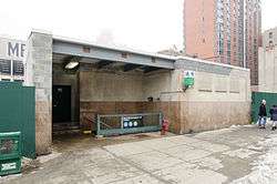
Due to its width, the southern (railroad eastern) half of the station had to be built under private property on the south side of Schermerhorn Street.[9] The station's mezzanine, located over the northern half of the station and under Schermerhorn Street, contains a New York City Transit Police substation where the operations of NYPD Transit District 30 are headquartered,[11][34] and several New York City Transit Authority offices. There are three staircases to each active platform,[29] a turnstile bank, a token booth, and two staircases to the streets. One leads to the northeast corner of Schermerhorn and Hoyt Streets, is built within the front entrance of 250 Schermerhorn Street, and connects to fare control via a corridor. The other staircase leads to the northwest corner of Bond and Schermerhorn Streets and is built inside a building housing the Goodwill Store and Donation Center.[35]
There are numerous sealed stairways and exits in the mezzanine, including a sealed passageway from the Bond Street exit to Livingston Street one block north, which had a direct entrance to the former Loeser's Department Store.[11][19][36] Part of the mezzanine tilework at this location still features navy blue and gold Art Deco designs, including large plaques bearing the store's logo.[11][37][38] These had previously been shop windows.[11] A control tower is located at the eastern (railroad south) end of the outer southbound platform, and is staffed at all times except late nights.[31]
Service patterns
| Bergen Street (IND Culver Line) | Jay Street – MetroTech (IND Fulton Street Line) | Court Street (IND Fulton Street Line) |
|---|---|---|
| West of the station | ||
| IND Crosstown Line G |
IND Eighth Avenue Line tunnels A C |
IND Fulton Street Line to Court Street no regular service |
| In the station | ||
| innermost tracks G |
center tracks A C |
outermost tracks no regular service |
| East of the station | ||
| IND Crosstown Line G |
IND Fulton Street Line express A |
IND Fulton Street Line local A C |
| Fulton Street (IND Crosstown Line) | Nostrand Avenue (IND Fulton Street Line) | Lafayette Avenue (IND Fulton Street Line) |
In popular culture
The Hoyt–Schermerhorn Streets station was featured in The Wiz (1978) in which the characters find themselves in a strange Emerald city subway with evil monsters such as chomping trashcans and subway columns that move and try to trap the characters. The station's mezzanine was the main setting for the filming of Michael Jackson's music video/short film for his hit 1987 single "Bad", as well as "Weird Al" Yankovic's parody, "Fat". In 1990, the station was also featured in the 1988 Eddie Murphy comedy Coming to America, where the main character boards an E train, as well as in the Paul Hogan adventure comedy Crocodile Dundee II. It was used as the subway stop for City Hall in Teenage Mutant Ninja Turtles.[39]
The opening scene of the Law & Order episode "Subterranean Homeboy Blues" (1990) was filmed in this station, with Cynthia Nixon's character, Laura di Biasi, boarding a train. In 1991, the station was featured in a shootout scene for the Michael J. Fox and James Woods buddy cop movie The Hard Way, showing an A train and a background with the Nostrand Avenue stop. The Warriors (1979) and The Taking of Pelham 123 (2009) have also filmed at Hoyt–Schermerhorn Streets.[39]
References
- 1 2 "NEW SUBWAY LINK OPENED BY MAYOR; He Tells 15,000 in Brooklyn It Will Be Extended to Queens When Red Tape Is Cut.". The New York Times. 1936-04-09. ISSN 0362-4331. Retrieved 2016-08-15.
- ↑ "Facts and Figures: Annual Subway Ridership". New York: Metropolitan Transportation Authority. Retrieved 2016-04-19.
- 1 2 Snapp, Fletcher G. (April 24, 1929). "Newtown Creek Tunnel First Tube of Kind Bored Without Compressed Air". Brooklyn Daily Eagle. p. 3. Retrieved 28 August 2016 – via Newspapers.com.
- 1 2 "Progress is Rapid on 8th Av. Subway: Board's Engineers Report Spurt in Building Is Likely to Open the Line in July, 1930". The New York Times. May 26, 1930. Retrieved 28 August 2016.
- ↑ "New Fulton Street Subway Officially Started as Byrne Turns Earth; Ground is Broken For Subway Line Along Fulton St.; Byrne Turns First Spade of Arlington Pl. Earth as Merchants Applaud.". Brooklyn Daily Eagle. April 17, 1929. p. 4. Retrieved 28 August 2016 – via Newspapers.com.
- ↑ Pullis, G.W. (September 23, 1928). "Smith Street between Schermerhorn Street and State Street along the 8th Avenue IND Line". New York Transit Museum. Retrieved 28 August 2016.
- ↑ Foley, A.J. (November 22, 1929). "Baptist Temple on 3rd Ave. & Schermerhorn St.: IND Crosstown Line". New York Transit Museum. Retrieved 28 August 2016.
- ↑ Pullis, G.W. (October 20, 1929). "Schermerhorn Street, Brooklyn, New York". New York Transit Museum. Retrieved 28 August 2016.
- 1 2 "City Will Raze Church to Make Way for Tubes: Action Will Be Started Soon to Get Property of Our Lady Mercy". Brooklyn Daily Eagle. January 8, 1930. p. 19. Retrieved 28 August 2016 – via Newspapers.com.
- ↑ "Church of Our Lady of Mercy (Roman Catholic)". American Guild of Organists. Retrieved 28 August 2016.
- 1 2 3 4 5 6 7 8 9 Jonathan Lethem (18 December 2007). "3". The Disappointment Artist: Essays (PDF). Knopf Doubleday Publishing Group. pp. 43–58. ISBN 978-0-307-42840-0. Retrieved 28 August 2016.
- ↑ Foley, A.J. (September 9, 1929). "Plank Road Collapse Along Schermerhorn Street; IND Crosstown Line". New York Transit Museum. Retrieved 28 August 2016.
- ↑ Foley, A.J. (September 9, 1929). "View of Plank Road Collapse Along Schermerhorn Street; IND Crosstown Line". New York Transit Museum. Retrieved 28 August 2016.
- 1 2 3 4 5 6 7 8 9 Egan, Leo (April 5, 1936). "Brooklyn's New $53,000,000 Subway Line Ready to Open Wednesday Night". Brooklyn Daily Eagle. p. 16. Retrieved 28 August 2016 – via Newspapers.com.
- ↑ "New Crosstown Subway Line Is Opened". Brooklyn Daily Eagle. July 1, 1937. Retrieved 24 December 2015.
- ↑ "Two Subway Links Start Wednesday". The New York Times. April 6, 1936. p. 23. Retrieved October 7, 2011.
- ↑ "IND Fulton Street Line". www.nycsubway.org. Retrieved 2016-02-18.
- ↑ "Notice of Public Hearing". Brooklyn Daily Eagle. October 6, 1936. p. 28. Retrieved 28 August 2016 – via Newspapers.com.
- 1 2 "Loeser's Gets Tunnel To Join With Subway". Brooklyn Daily Eagle. November 21, 1937. p. 3. Retrieved 28 August 2016 – via Newspapers.com.
- ↑ Jaffe, Alfred (December 6, 1946). "Borough Subway Relief Still 2 or 3 Years Off". Brooklyn Daily Eagle. pp. 1, 5. Retrieved 9 October 2015 – via Newspapers.com.
- ↑ Blauvelt, Paul (June 9, 1946). "Shortages Snarl $50,000,000 Tube Links". Brooklyn Daily Eagle. p. 21. Retrieved 9 October 2015 – via Newspapers.com.
- 1 2 3 "Special Aqueduct Subway Service: Premium Fare Trains Started By T.A. To Local Race Track" (PDF). Wave of Long Island. Fultonhistory.com. September 17, 1959. p. 5. Retrieved 15 August 2016.
- 1 2 3 O'Neill, Natalie (March 29, 2012). "Peeling ceiling is latest problem for G train riders". Brooklyn Paper. Retrieved 28 August 2016.
- ↑ Chan, Sewell (2005-11-30). "New Subway Cars Promise All Kinds of Information". The New York Times. Retrieved 2007-10-27.
- 1 2 Calder, Rich (2009-09-02). "Jacko Off Tracko". New York Post. Retrieved 2009-09-09.
- 1 2 3 Lee, Jennifer S. (August 28, 2009). "A Compromise for the Michael Jackson Subway Station". The New York Times. Retrieved 28 August 2016.
- ↑ Fernandez, Manny (2009-08-27). "Brooklyn Sets Aside a Day for a Michael Jackson Party". The New York Times. Retrieved 2016-09-20.
- 1 2 3 4 5 Marrero, Robert (2015-09-13). "469 Stations, 846 Miles" (PDF). B24 Blog, via Dropbox. Retrieved 2015-10-09.
- 1 2 3 4 "Review of the G Line: Appendices" (PDF). Metropolitan Transportation Authority. July 10, 2013. Retrieved 28 October 2015.
- ↑ "Review of the A and C Lines" (PDF). Metropolitan Transportation Authority. December 11, 2015. Retrieved 19 January 2016.
- 1 2 "Review of the G Line" (PDF). mta.info. Metropolitan Transportation Authority. July 10, 2013. Retrieved 2 August 2015.
- 1 2 "The New York City Filming Locations of The Warriors – Part 3". Scouting New York. May 22, 2013. Retrieved 10 September 2016.
- ↑ "Audit Report on the New York City Transit Authority's Track Cleaning and Paining of the Subway Stations" (PDF). nyc.gov. Office of the New York City Comptroller. May 14, 2015. Retrieved 28 August 2016.
- ↑ "Transit Bureau - Transit District 30". nyc.gov. New York City Police Department. Retrieved 28 August 2016.
- ↑ "MTA Neighborhood Maps: Downtown Brooklyn" (PDF). mta.info. Metropolitan Transit Authority. 2015. Retrieved 28 July 2016.
- ↑ Walsh, Kevin (December 14, 2009). "BOERUM HILL, Brooklyn". Forgotten New York. Retrieved 28 August 2016.
- ↑ Fox, Margalit; Robinson, George (August 17, 2003). "F.Y.I.". The New York Times. Retrieved 28 August 2016.
- ↑ Walsh, Kevin (June 7, 1998). "THE SUBWAYS REMEMBER with ancient signage". Forgotten New York. Retrieved 28 August 2016.
- 1 2 "www.nycsubway.org: Subway Movies and Documentaries". www.nycsubway.org. Retrieved 2016-07-28.
External links
| Wikimedia Commons has media related to Hoyt–Schermerhorn Streets (New York City Subway). |
- nycsubway.org – IND Fulton: Hoyt–Schermerhorn Street
- Station Reporter — A Lefferts
- Station Reporter — A Rockaway
- Station Reporter — C Train
- Station Reporter — G Train
- Abandoned Stations: Court St, and Hoyt-Schermerhorns Sts platforms
- The Subway Nut — Hoyt–Schermerhorn Streets Pictures
- Hoyt Street entrance from Google Maps Street View
- Bond Street entrance from Google Maps Street View