Hudson Strait
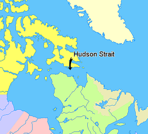
Hudson Strait links the Atlantic Ocean to Hudson Bay in Canada. This strait lies between Baffin Island and the northern coast of Quebec, with its eastern entrance marked by Cape Chidley in Quebec and Resolution Island off Baffin Island. The strait is about 450 mi (720 km) long. Its width varies from 150 mi (240 km) at its largest point, to a minimum of 40 mi (64 km).[1][2]
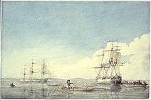
The entrance to Hudson Strait was discovered in 1578 by Sir Martin Frobisher, the English navigator, who named a tidal rip at the entrance the Furious Overfall, and called the strait Mistaken Strait, since he felt it held less promise as an entrance to the Northwest Passage than the body of water that was later named Frobisher Bay. The name was changed to Hudson Strait in honor of the first European to sail beyond the Furious Overfall in 1610: English explorer Henry Hudson in the English ship Discovery. Hudson was followed by Thomas Button in 1612, and a more detailed mapping expedition led by William Baffin in 1615.
Hudson Strait links the northern seaports of Manitoba and Ontario with the Atlantic Ocean. It could be an eastern entrance to the Northwest Passage were it not for ice in the Fury and Hecla Strait south of western Baffin Island.
Extent
The International Hydrographic Organization defines the limits of the Hudson Strait as follows:[3]
- On the West.A line from Nuvuk Point (62°21′N 78°06′W / 62.350°N 78.100°W) to Leyson Point, thence by the Eastern shore of Southampton Island to Seahorse Point, its Eastern extreme, thence a line to Lloyd Point (64°25′N 78°07′W / 64.417°N 78.117°W) Baffin Island.
- On the North. The South coast of Baffin Island between Lloyd Point and East Bluff.
- On the East. A line from East Bluff, the Southeast extreme of Baffin Island (61°53′N 65°57′W / 61.883°N 65.950°W), to Point Meridian, the Western extreme of Lower Savage Islands, along the coast to its Southwestern extreme and thence a line across to the Western extreme of Resolution Island, through its Southwestern shore to Hatton Headland, its Southern point, thence a line to Cape Chidley, Labrador (60°24′N 64°26′W / 60.400°N 64.433°W).
- On the South. The mainland between Cape Chidley and Nuvuk Point.
References
- ↑ Trémaudan, Auguste Henri de Trémaudan (1916). The Hudson Bay road (1498–1915) (Digitized 10 July 2008 ed.). J.M. Dent. p. 50.
- ↑ answers.com
- ↑ "Limits of Oceans and Seas, 3rd edition" (PDF). International Hydrographic Organization. 1953. Retrieved 6 February 2010.
Further reading
- Allard, Michel, Baolai Wang, and Jean A Pilon. 1995. "Recent Cooling Along the Southern Shore of Hudson Strait, Quebec, Canada, Documented from Permafrost Temperature Measurements". Arctic and Alpine Research. 27, no. 2: 157.
- Andrews, J. T., and D. C. Barber1. 2002. "Dansgaard-Oeschger Events: Is There a Signal Off the Hudson Strait Ice Stream?" Quaternary Science Reviews. 21, no. 1-3: 443–454.
- Barr, W. 1994. "The Eighteenth Century Trade between the Ships of the Hudson's Bay Company and the Hudson Strait Inuit". Arctic. 47, no. 3: 236.
- Campbell, N. J. The Oceanography of Hudson Strait. [S.l.]: Atlantic Oceanographic Group, 1958.
- Easton, A. K. Tides of Hudson Strait. Dartmouth, Nova Scotia: Bedford Institute of Oceanography, 1972.
- Gaston, A. J. Seabird Investigations in Hudson Strait Report on Activities in 1980. OLABS Program report. [Canada]: Canadian Wildlife Service, 1981.
- Payne, F. F. Eskimo of Hudson's Strait. Toronto?: s.n.], 1889. ISBN 0-665-09301-2
- 2005. "A Sentry at the Atlantic Gateway – An Experimental Mooring Monitors Water Flow Through Strategic Hudson Strait". Oceanus. 44, no. 3: 30.
| Wikimedia Commons has media related to Hudson Strait. |
Coordinates: 62°29′36″N 071°57′43″W / 62.49333°N 71.96194°W