Hughes Peninsula
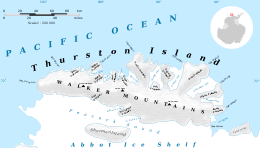
Map of Thurston Island.
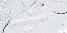
Satellite image of Thurston Island.
Hughes Peninsula (71°54′S 100°17′W / 71.900°S 100.283°WCoordinates: 71°54′S 100°17′W / 71.900°S 100.283°W) is an ice-covered peninsula about 18 nautical miles (33 km) long, lying west of Henry Inlet on the north side of Thurston Island, Antarctica. It was plotted from air photos taken by U.S. Navy Operation Highjump in December 1946, and was named by the Advisory Committee on Antarctic Names for Jerry Hughes, a photographer's mate with the U.S. Navy Bellingshausen Sea Expedition in February 1960, who took aerial photographs of Thurston Island from helicopters.[1]
Maps
- Thurston Island – Jones Mountains. 1:500000 Antarctica Sketch Map. US Geological Survey, 1967.
- Antarctic Digital Database (ADD). Scale 1:250000 topographic map of Antarctica. Scientific Committee on Antarctic Research (SCAR), 1993–2016.
References
- ↑ "Hughes Peninsula". Geographic Names Information System. United States Geological Survey. Retrieved 2012-07-02.
![]() This article incorporates public domain material from the United States Geological Survey document "Hughes Peninsula" (content from the Geographic Names Information System).
This article incorporates public domain material from the United States Geological Survey document "Hughes Peninsula" (content from the Geographic Names Information System).
This article is issued from Wikipedia - version of the 1/29/2016. The text is available under the Creative Commons Attribution/Share Alike but additional terms may apply for the media files.