Hulme End

Introduction
Hulme End is a small hamlet in Staffordshire, England. It is located in the Peak District National Park about 10 miles north of Ashbourne. A natural gateway to the Manifold valley, the settlement is located beside the river Manifold where it crosses the road from Hartington (the nearest small town) to Warslow.
Although in the county of Staffordshire, the hamlet lies close to the Derbyshire border, and in fact has a Derbyshire postal address, i.e. Hulme End, Hartington, Buxton, Derbyshire.
The Leek and Manifold Light Railway
The hamlet's primary significance stems from its position as the northern terminus of the former Leek and Manifold Valley Light Railway, an independent narrow gauge (2 ft 6 in (762 mm)) line built following the legislation of the Light Railways Act 1896 which let companies to construct short lines to serve more isolated places.
The line primarily acted as a service for milk trains and tourism. On the timetable Hulme End was described as "Hulme End for Hartington" (Hartington is some 3 miles distant).
During the railway's lifetime there was some talk of extending the line northwards towards Buxton (10 miles to the north), whereby Hulme End, with its engine and carriage sheds, would have become a natural half-way point of the line, with probable considerable resultant growth - and survival of the railway - but this never materialised.
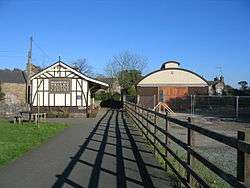
Today the old station building has been fully restored, complete with mock beams, and is now a staffed visitor centre, open most weekends & during school holidays. Information displays outline a brief history of the railway and there is a small collection of memorabilia from the line. The centre supplies the usual range of souvenirs, guide books, maps & leaflets. Within the building are public toilets, and there is a pay-and-display car park.
Adjacent to the station, the former engine has been rebuilt to a similar design as the original; a small part of the original frameworks exists inside. The former coach sheds, which similarly had two roads, have not survived.
In 1937 the former railway was re-opened by the County Council as the Manifold Way, an 8-mile tarmacked leisure route for walkers and cyclists, some of whom use the local campsite. The only such route in the Peak District to have a metalled surface throughout its entire length, it is also ideally suited to wheelchairs and prams. Hulme End, which is served by buses, is now the start point at its northern end.
The Manifold Inn
The Manifold Inn, formerly called The Light Railway, is located beside the river Manifold. Despite its name, it is a 200-year-old coaching inn. Opposite the pub is the Old Toll House, which at one time served the turnpike and river ford. The bridge that the Toll House sits on was originally built in 1790, but most of the original bridge has subsequently been replaced due to damage and collapse. The current bridge has been there since 1819.
Around the Village
The village also supports a small shop which stocks a huge range of products in a very small space. It is owned by a live-in couple called Eric and Judy.Unfortunately the store closed upon the retirement of the owners in 2012/13.
Opposite the Manifold Inn there are farm buildings which are now part of a well-run campsite. The earliest records of this farm date back to when A.T Bury, a doctor, resided in it. The three-storeyed Hulme End Farm on the site was bought in the late 1880s by the medical practitioner who enlarged the house and renamed it Bank House. In 1967 his grandson, Robert Bury, rebuilt the older part, which was suffering from subsidence. This campsite and farm buildings are now collectively called Bank House Park. Bank House Park was once a farm called Bank House Farm. It used to be owned by Robert Bury, a farmer, who lived in the farm house named. After his death it was run briefly by the Manifold Inn. The campsite is now being managed by a young couple who live in the cottage on the campsite all year round. The campsite is open from March until October and has excellent shower, toilet, drinking water and chemical disposal facilities. It also has washing up areas and extensive recycling facilities. More facilities are due to be added, planning permission pending.
See also
References
Keys R and Porter L (1972) The Manifold Valley and its Light Railway, Moorland publishers
External links
| Wikimedia Commons has media related to Hulme End. |
Coordinates: 53°07′52″N 1°50′47″W / 53.13111°N 1.84639°W