Husby, Stockholm

Husby is a district (Swedish: stadsdel) in Rinkeby-Kista borough, Stockholm, Sweden.[1] Husby has 11,551 inhabitants as of December 31, 2007.[2] T
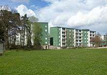
Husby is located on the blue Metro line. The main construction of modern Husby, with its multi-level concrete apartment buildings, started in 1972 as part of the Million Programme. The subway station was opened in 1977 and the train takes approx. 20 minutes to Stockholm City. The name of the suburb was taken from a former royal farm, still located in the area. The streets of Husby are named after cities in Norway. There are many runestones in the surroundings of Husby, remnants from when Vikings used to live here.
Husby has the lowest income per capita of any district of Stockholm.[3] 2014, more than 80% of the population had miniority background, mostly from Middle-east and Africa.[4]
2013 riots
In May 2013, the district was the center of worldwide attention, due to riots that spread to several other parts of Stockholm. Over the course of three days, approximately 129 cars were burned, garages were set on fire, and the rioters engaged in sporadic clashes with the police. The rioters were mainly members of immigrant communities, especially Iraqi and Somalian[5]
Notable people from Husby
See also
References
| Wikimedia Commons has media related to Husby, Stockholm. |
- ↑ "Administrative divisions of the City districts". Stockholms stads utrednings- och statistikkontor AB. 2008-04-14. Retrieved 2008-06-03.
- ↑ "Områdesfakta Husby stadsdel". Stockholms stads utrednings- och statistikkontor AB. Retrieved 2008-06-08.
- ↑ http://www.statistikomstockholm.se/attachments/article/38/arsbok_2015.pdf
- ↑ Peter Saltin. "Detaljerad statistik". statistikomstockholm.se.
- ↑ http://www.theguardian.com/world/2013/may/25/sweden-europe-news. Retrieved 30 May 2014. Missing or empty
|title=(help)
Coordinates: 59°24′34″N 17°55′37″E / 59.40944°N 17.92694°E