Idaho Centennial Trail
| Idaho Centennial Trail | |
|---|---|
|
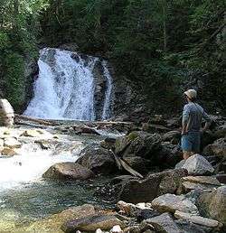
Priest Falls, the northern terminus of the Idaho Centennial Trail. | |
| Length | 900 mi (1448 km) |
| Location | Idaho, United States |
| Trailheads |
South: Murphy Hot Springs 41°59′46″N 115°19′06″W / 41.99612°N 115.31834°W North: Priest Falls 48°59′36″N 116°56′25″W / 48.99328°N 116.94019°W |
| Use |
Hiking Horse riding Biking |
| Elevation | |
| Highest point | Approx. 9,000 feet (2,743 m)[1] |
| Lowest point | 1,900 feet (579 m)[2] |
| Hiking details | |
| Trail difficulty | Moderate to Strenuous |
| Months | May to September |
| Sights | Boise National Forest, Bitterroot Mountains, Bitterroot National Forest, Clearwater National Forest, Frank Church-River of No Return Wilderness, Gospel Hump Wilderness, Nez Perce National Forest, Payette National Forest, Saylor Creek Bombing Range, Salmon-Challis National Forest, Sawtooth National Forest, Selway-Bitterroot Wilderness, Salmon River, Selway River |
| Hazards |
Severe Weather Dehydration Wildlife |
The 900-mile (1,448 km) Idaho Centennial Trail (ICT) is a scenic trail through Idaho. It winds its way through various ecosystems from high desert canyonlands in southern Idaho to wet mountain forests in Northern Idaho. ICT travelers will cross many mountains, streams and rivers in between. Below find information about the Idaho Centennial Trail in regards to its history, route, elevation gain and loss, controlling agencies, maps, and trail guide.
History
The notion of a trail connecting the Northern and Southern borders of Idaho was first envisioned in the early 1980s.[3] Roger Williams and Syd Tate came up with the idea in 1986. Williams and Tate made a challenging three-month-long, twelve hundred mile journey over the entire length of Idaho and in the process the idea of an official trail route was born.
The ICT was designated as the official state trail[4] during Idaho’s Centennial year in 1990 by the Lasting Legacy Committee of the Idaho Centennial Commission.[3] Since then the number of hikers completing the trail have remained low.[2]
Route

The Idaho Centennial Trail (ICT) route is along existing trails and primitive roads. Hikers typically start at the southern trailhead[2] near Murphy Hot Springs on the Idaho-Nevada border in early June when snow levels are starting to recede and travel northward through high desert with the goal of entering higher country before the heat of summer sets in. As thru-hikers approach the Sawtooth Mountains the snows have receded enough by mid-July to allow for easier and safer travel. The end of the trail at the Idaho-British Columbia border must then be reached before the snows of late September/early October.
The ICT is located in the Sawtooth Wilderness, the Frank Church-River of No Return Wilderness and the Selway-Bitterroot Wilderness for more than 300 miles (483 km). Within these areas the trail borders Middle Fork of the Salmon River and the Selway River. These rivers are both bestowed with the designation as National Wild and Scenic Rivers a designation due largely to Frank Church of whom one of Idaho's Wilderness areas is named.[5]
North of the Selway-Bitterroot, the trail hop-scotches along the Idaho-Montana border on the backbone of the Bitterroot Mountains for more than 85 miles (137 km) on high ridges. Dozens of high mountain lakes along this portion of the route will beckon angler and those who delight in scenery.
Elevation Gain and Loss
The trail features many climbs and descents losing and gaining elevation to cross a river or canyon, and then climbing once again to a high ridge. The Centennial Trail begins at 6,000 feet (1,829 m) near Murphy Hot Springs, descends to 2,500 feet (762 m) at the Snake River near Glenns Ferry, and then yo-yos up and down through the mountains of Central Idaho between 3,000 (914 m) and 9,000 feet (2,743 m). The trail’s low point (1,900 feet (579 m) above sea level) is along the Selway River near the Moose Creek Guard Station, and then it climbs again to high points between 5,000 (1,524 m) and 6,000 feet (1,829 m) in the Cabinet Mountains and Selkirk Mountains as the trail approaches the northern boundary.
Controlling Agencies
The Idaho State Centennial Trail is a cooperative effort. The Idaho Department of Parks and Recreation provides overall trail coordination. The Bureau of Land Management manages of southern section of trail. The U.S. Forest Service manages of the middle and northern sections of the trail and private and other public land agencies allow trail users to cross their property for continuity.
Maps
U.S. Forest Service maps, Bureau of Land Management maps, and U.S. Geological Survey (USGS) 1-24,000 scale topographic hard copy maps or topographic software such as National Geographic TOPO! are recommended for planning and on-trail use. A trail map is available for digital download in seventy-six separate PDF files at the Idaho Parks and Recreation Department Web site (see links section below). The link below does not lead to the PDF files but they can be found by searching the Idaho Parks and Recreation Web site.
Trail Guide
In 1998 Stephen Stuebner's Idaho Centennial Trail Guidebook was published.[6] This guidebook, although well written is considered to be out of date by the Idaho Centennial Trail coordinator, Leo Hennessey.
References
- ↑ "Idaho's Centennial Trail - Coordinator".
- 1 2 3 "Idaho Centennial Trail". Archived from the original on September 5, 2008.
- 1 2 "Idaho's Centennial Trail - Trail Originators".
- ↑ "Idaho Centennial Trail Blog".
- ↑ "Wild and Scenic Rivers".
- ↑ "ULA - Ultralight Adventure Equipment". Archived from the original on October 15, 2008.
External links
| Wikimedia Commons has media related to Idaho Centennial Trail. |
- Idaho Parks and Recreation Centennial trail map
- Centennial Trail Trail description and information from the State of Idaho Parks and Recreation
- Official Trail Maps A digital representation of the ICT
- Ultralight Adventure Equipment Thru-hiker's journal, photos and information
- Idaho Centennial Trail Blog Blog for hikers of the ICT
- Idaho's Centennial Trail Outdoor Idaho DVD