Incahuasi
This article is about a volcano on the border between Argentina and Chile. For other uses, see Inka Wasi.
| Incahuasi | |
|---|---|
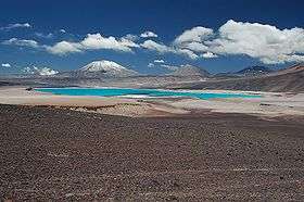 The volcanoes Incahuasi (left) and El Fraile behind the colorful Laguna Verde (lake). | |
| Highest point | |
| Elevation | 6,621 m (21,722 ft) [1] |
| Prominence | 1,518 m (4,980 ft) [1] |
| Listing | Ultra |
| Coordinates | 27°02′00″S 68°17′45″W / 27.03333°S 68.29583°WCoordinates: 27°02′00″S 68°17′45″W / 27.03333°S 68.29583°W [1] |
| Geography | |
 Incahuasi Location in Argentina, on the border with Chile | |
| Location |
Catamarca, Argentina - Atacama, Chile |
| Parent range | Andes |
| Geology | |
| Mountain type | stratovolcanoes and caldera |
| Last eruption | Unknown |
| Climbing | |
| First ascent | 1913 by Walther Penck |
Incahuasi (Spanish pronunciation: [iŋkaˈwasi]; Quechua Inkawasi or Inka Wasi, inka Inca, wasi house,[2][3] "Inca house") is a volcanic mountain in the Andes of South America. It lies on the border of the Argentine province of Catamarca, and the Atacama Region of Chile. Incahuasi has a summit elevation of 6,621 metres (21,722 ft) above sea level.
The volcano consists of a 3.5-kilometre-wide (2.2 mi) caldera and two stratovolcanoes. Four pyroclastic cones are located 7 kilometres (4.3 mi) to the north-east and produced basalt-andesite lava flows that cover an area of 10 square kilometres (4 sq mi).[4]
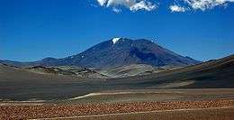
Incahuasi Volcan from Route 60, Catamarca, Argentina
See also
- List of volcanoes in Chile
- List of volcanoes in Argentina
- List of Ultras of South America
- Ojos del Salado
- Nevado Tres Cruces
- Cerro El Muerto
References
- 1 2 3 "Argentina and Chile North: Ultra-Prominences" Peaklist.org. Retrieved 2013-02-25.
- ↑ Diccionario Quechua - Español - Quechua, Academía Mayor de la Lengua Quechua, Gobierno Regional Cusco, Cusco 2005 (Quechua-Spanish dictionary)
- ↑ Teofilo Laime Ajacopa, Diccionario Bilingüe Iskay simipi yuyayk'ancha, La Paz, 2007 (Quechua-Spanish dictionary)
- ↑ http://www.volcanolive.com/incahuasi.html
External links
- "Incahuasi". SummitPost.org.
- Incahuasi (Spanish)
- "Cerro de Incahuasi, Argentina/Chile" on Peakbagger
This article is issued from Wikipedia - version of the 5/8/2015. The text is available under the Creative Commons Attribution/Share Alike but additional terms may apply for the media files.