Indian Heaven
| Indian Heaven | |
|---|---|
 Lemei Rock in the Indian Heaven volcanic field | |
| Highest point | |
| Elevation | 5,925 ft (1,806 m) |
| Coordinates | 45°56′00″N 121°49′00″W / 45.93333°N 121.81667°WCoordinates: 45°56′00″N 121°49′00″W / 45.93333°N 121.81667°W [1] |
| Geography | |
| Location | Skamania County, Washington, U.S. |
| Parent range | Cascade Range |
| Geology | |
| Age of rock | Pleistocene and Holocene |
| Mountain type | volcanic field |
| Volcanic arc | Cascade Volcanic Arc |
| Last eruption | 6250 BCE ± 100 years |
| Climbing | |
| Easiest route | Lemei Trail, Indian Heaven Trail, with rock scrambling |
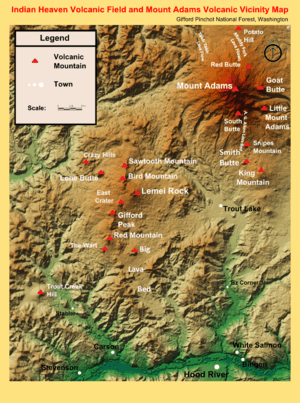
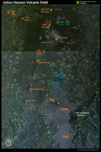
Indian Heaven is a polygenetic volcanic field in Washington, United States.[2] It is located midway between Mount St. Helens and Mount Adams, and dates from the Pleistocene and Holocene. The field trends north to south and is dominated by seven small shield volcanoes that may have each erupted only once.[3] Those shields are topped by small spatter and cinder cones. The northernmost peak in the field is Sawtooth Mountain and the southernmost is Red Mountain. The highest point is Lemei Rock at 5,925 feet (1,806 m).[4] Its last volcanic activity produced a large cinder cone and a voluminous lava and scoria flows about 8,200 years ago.
About 60 eruptive centers lie on the 19-mile (30 km) long, N10°E-trending, Indian Heaven fissure zone. The 230-square-mile (600 km2) field has a volume of about 20 cubic miles (100 km3) and forms the western part of a 770-square-mile (2,000 km2) Quaternary basalt field in the southern Washington Cascades, including the King Mountain fissure zone along which Mount Adams was built.
Notable vents
| Name | Elevation | Location | Last eruption | |
| meters | feet | Coordinates | ||
| Big Lava Bed[2] | 1,278.6 | 4,195 | 45°54′N 121°45′W / 45.9°N 121.75°W | ~8150 years ago |
| Bird Mountain[2] | 1,739 | 5,705 | 46°02′21″N 121°46′52″W / 46.0392°N 121.78106°W | - |
| Crazy Hills[2] | - | |||
| East Crater[2] | 1,614 | 5,295 | 46°00′N 121°47′W / 46°N 121.78°W | - |
| Gifford Peak[2] | 1,614 | 5,295 | - | |
| Lemei Rock[2] | 1,806 | 5,925 | 46°1′6″N 121°45′36″W / 46.01833°N 121.76000°W | - |
| Lone Butte[2] | 1,457 | 4,780 | 46°03′N 121°52′W / 46.05°N 121.87°W | - |
| Red Mountain[2] | 1,513 | 4,964 | 45°56′N 121°49′W / 45.93°N 121.82°W | - |
| Sawtooth Mountain[2] | 1,632 | 5,354 | 46°04′N 121°47′W / 46.07°N 121.78°W | - |
Visitation
Popular fishing and hiking destinations in the volcanic field include the Indian Heaven Wilderness, which is rather popular for the high mountain meadows among its scattered volcanic peaks. The Pacific Crest National Scenic Trail passes north/south through the volcanic field and the Indian Heaven Wilderness, which is known for its many lakes and spectacular views of four nearby volcanoes: Mount Adams, Mount Hood, Mount St. Helens, and Mount Rainier. It is also known to hikers for an intense population of mosquitoes throughout the summer. Other major trails in the area are Indian Heaven Trail and the Cultus Creek Trail, which climbs up the east side of Bird Mountain; and Lemei Trail which traverses up the east side of Lemei Rock and passes by Lake Wapiki.
The popular Goose Lake Campground, a favorite pastime with fishers,[5] is located right at the northernmost edge of the Big Lava Bed. The lake was originally created when the flow dammed up its outflow creek, resulting in a dead forest on the southern end of the lake. The shallow Forlorn Lakes, just northeast of Goose Lake, offers a day use area and a campground. Cultus Creek Campground offers visitors two major trail heads (Indian Heaven Trail #33 and Cultus Creek Trail #108) and popular huckleberry picking access to the Indian Heaven Wilderness, famous for its huckleberries,[6][7] and the volcanic field in which it resides.
See also
References
- ↑ "Indian Heaven". Global Volcanism Program. Smithsonian Institution. Retrieved 2009-01-16.
- 1 2 3 4 5 6 7 8 9 10 Wood, Charles A.; Kienle, Jűrgen (1993). Volcanoes of North America. Cambridge University Press. pp. 166–167. ISBN 0-521-43811-X.
- ↑ "Volcanoes". Washington State Department of Natural Resources. Retrieved 2014-05-11.
- ↑ "Lemei Rock". Summit Post. Retrieved 2013-03-30.
Lemei Rock is the highest point in the Indian Heaven Wilderness Area which is situated in the middle of the diamond formed by Rainier, St. Helens, Adams and Hood. It's a craggy remnant of a volcano whose crater is now Lake Wapiki.
- ↑ "GOOSE LAKE, WA". Reserve America. Retrieved 25 April 2013.
- ↑ "Wilderness: Indian Heaven". USDA Forest Service: Gifford Pinchot National Forest Official Website. Retrieved 25 April 2013.
- ↑ "Huckleberry Fields/Gifford Pinchot National Forest: Indian Heaven Wilderness, Gifford Pinchot, Skamania". thecentralcascades.com/. Retrieved 25 April 2013.
External links
| British Columbia |  | |
|---|---|---|
| Washington | ||
| Oregon | ||
| California | ||