Indian Nation Turnpike
| |
|---|---|
 | |
| Route information | |
| Length: | 105.2 mi (169.3 km) |
| Existed: | 1966 – present |
| Major junctions | |
| South end: |
|
| North end: |
|
| Location | |
| Counties: | Choctaw, Pushmataha, Atoka, Pittsburg, McIntosh, Okmulgee |
| Highway system | |

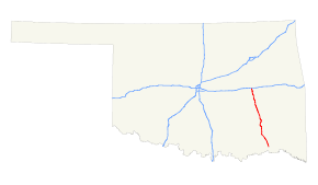
The Indian Nation Turnpike is a toll road in southeastern Oklahoma, United States, running between Hugo and Henryetta, Oklahoma, a distance of 105.2 miles (169.3 km). It is the longest tollway in the state.[1]
Route description
The Indian Nation turnpike is built to parkway-like design standards, omitting a center barrier and left-hand shoulders for a slightly mounded grassy median that is flush with the edge of the left lane in each direction. The turnpike's speed limit is 75 mph (121 km/h).
A two-axle vehicle pays $4.75 ($4.50 with Pikepass) to drive the full length of the Turnpike. *Toll has now increased to $5.50 (cash) for a full length trip as of 2013.
Law enforcement along the Indian Nation Turnpike is provided by Oklahoma Highway Patrol Troop XC, a special troop assigned to the turnpike.[2]
The only dining option along the entire turnpike is McDonald's.
History
The route is one continuous four-lane limited access highway, but consists of two separately constructed sections. The 41.1-mile (66.1 km) northern section, which opened in 1966, is the portion between I-40/US 62/US 75 near Henryetta and US 69 south of McAlester. The southern extension opened in 1970, and is the 64.1-mile (103.2 km) segment from the US 69 junction to US 70/271 in Hugo.
Exit list
| County | Location | mi[3] | km | Exit | Destinations | Notes |
|---|---|---|---|---|---|---|
| Choctaw | Hugo | 0.0 | 0.0 | 1 | Last free exit northbound, Turnpike begins; southbound continuation as | |
| Pushmataha | Antlers | 16.0 | 25.7 | 16 | Toll barrier under bridge prior to exit in both directions | |
| 16.4 | 26.4 | Antlers Service Plaza | ||||
| Atoka | Daisy | 38.4 | 61.8 | 38 | ||
| Pittsburg | | 63.2 | 101.7 | Toll barrier | ||
| | 63.3 | 101.9 | 63 | Signed as Exits #63B-A southbound | ||
| | 69.9 | 112.5 | 70 | |||
| | 82.0 | 132.0 | 82 | Canadian, Indianola | Northbound entrance and southbound exit | |
| McIntosh | | 92.8 | 149.3 | 92 | Toll barrier under bridge prior to exit in both directions | |
| | 92.9 | 149.5 | Eufaula Service Plaza | |||
| Henryetta | 104.4 | 168.0 | 104A | Last free exit southbound; I-40 exit 240A | ||
| 104.7 | 168.5 | 104B | Turnpike ends, northbound continuation as | |||
| 105.2 | 169.3 | E. Main St. | Freeway ends | |||
1.000 mi = 1.609 km; 1.000 km = 0.621 mi
| ||||||
See also
References
- ↑ "OKHighways.com - Indian Nation Turnpike". OK Highways. Retrieved July 30, 2014.
- ↑ "Oklahoma Highway Patrol". Retrieved 2008-04-05.
- ↑ Google (2011-01-05). "Overview map of Indian Nation Turnpike Distances Between Interchanges" (Map). Google Maps. Google. Retrieved 2011-01-05.