Indiana State Road 362
| ||||
|---|---|---|---|---|
 | ||||
| Route information | ||||
| Maintained by INDOT | ||||
| Length: | 7.415 mi[1] (11.933 km) | |||
| Major junctions | ||||
| West end: |
| |||
| East end: |
| |||
| Location | ||||
| Counties: | Clark, Jefferson, Scott | |||
| Highway system | ||||
| ||||

State Road 362 in the U.S. state of Indiana is a short seven-mile (11 km) route in the southeastern portion of the state.
Route description
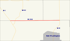
State Road 362 straddles the Clark County border with Scott and Jefferson counties. It begins at State Road 3 near Garry's Trucking Service and runs directly east along the county line, intersecting with State Road 203 and passing through the town of Nabb. It terminates where it reaches State Road 62 north of New Washington.
Major intersections
| County | Location | mi[1] | km | Destinations | Notes |
|---|---|---|---|---|---|
| Scott–Clark county line | Lexington–Oregon township line | 0.000 | 0.000 | Western terminus of SR 362 | |
| 0.714 | 1.149 | Southern terminus of SR 203 | |||
| Jefferson–Clark county line | Saluda–Washington township line | 7.415 | 11.933 | Eastern terminus of SR 362 | |
| 1.000 mi = 1.609 km; 1.000 km = 0.621 mi | |||||
References
- 1 2 Indiana Department of Transportation (July 2015). Reference Post Book (PDF). Indianapolis: Indiana Department of Transportation. Retrieved October 1, 2016.
External links
This article is issued from Wikipedia - version of the 11/29/2016. The text is available under the Creative Commons Attribution/Share Alike but additional terms may apply for the media files.