Inner-Vikna
 | |
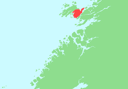 Location in Nord-Trøndelag | |
| Geography | |
|---|---|
| Location | Nord-Trøndelag, Norway |
| Coordinates | 64°53′19″N 11°14′25″E / 64.8887°N 11.2403°ECoordinates: 64°53′19″N 11°14′25″E / 64.8887°N 11.2403°E |
| Area | 99.2 km2 (38.3 sq mi) |
| Length | 14 km (8.7 mi) |
| Width | 7.5 km (4.66 mi) |
| Highest elevation | 162 m (531 ft) |
| Highest point | Vattafjellet |
| Administration | |
| County | Nord-Trøndelag |
| Municipality | Vikna |
| Demographics | |
| Population | 3200 (2001) |
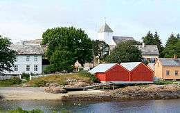
Inner-Vikna (sometimes Indre Vikna) is the largest of the three major islands in the municipality of Vikna in Nord-Trøndelag county, Norway. The 99.2-square-kilometre (38.3 sq mi) island is located in the eastern part of the municipality and it includes Rørvik, the administrative centre of Vikna.
Norwegian County Road 770 runs across the island, and also passing by Rørvik Airport, Ryum, then it continues over the Nærøysund Bridge and Marøysund Bridge to connect the island to the mainland. The relatively flat and barren island is separated from the mainland by the Nærøysundet strait.[1]
See also
References
- ↑ Store norske leksikon. "Indre Vikna" (in Norwegian). Retrieved 2011-10-04.
This article is issued from Wikipedia - version of the 11/17/2016. The text is available under the Creative Commons Attribution/Share Alike but additional terms may apply for the media files.