Inner Ring Road (Shanghai)
| Shanghai Inner Ring Road | |
|---|---|
| 上海内环线 | |
|
Inner Ring Elevated Road 内环高架路 | |
 | |
|
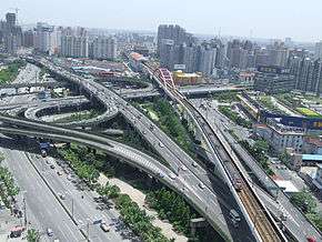
The Inner Ring Road at the North Caoxi Road Interchange with Humin Elevated Road. | |
| Route information | |
| Length: | 47.7 km[1] (29.6 mi) |
| Existed: | October 1994[2] – present |
| Major junctions | |
| Orbital around Shanghai | |
|
Counterclockwise from Yangpu Bridge: Yixian Elevated Road at Dabaishu Interchange South-North Elevated Road at Gonghexin Road Interchange Yan'an Elevated Road at West Yan'an Road Interchange Humin Elevated Road at North Caoxi Road Interchange North-South Elevated Road at Luban Road Interchange South Yanggao Road at Longyang Road Interchange Luoshan Road and Longdong Avenue at Zhangjiang Interchange Middle Yanggao Road at Luoshan Road Interchange | |
| Highway system | |
| Expressways of Shanghai | |
Inner Ring Road (Chinese: 上海内环线; pinyin: Shànghǎi Nèihuánxiàn; literally: "Shanghai Inner Ring Line"), also known as Inner Ring Elevated Road (Chinese: 内环高架路; pinyin: Nèihuán Gāojiàlù), is an elevated expressway in the city of Shanghai, China. It was the first ring road around the city of Shanghai. The Puxi section of the road was completely grade-separated and complete in 1994, while the Pudong section of the road was completely grade-separated in 2009.[2] Before the grade separation in Pudong, the road ran at street level, with traffic lights at intersections.
The maximum speed on the expressway is 80 kilometres per hour (50 mph), with two lanes in each direction. The Inner Ring Road crosses the Huangpu River twice, using the Yangpu and Nanpu bridges.
Exit List
- Zhongshan S Road (CW exit and CCW entrance)
- Lujiabang Road (CW exit and CCW entrance)
- Nanchezhan Road, Xizang S Road (No CW entrance)
- North-South Elevated Road
- Dapu Rd, Ruijin S Rd, Rihui E Road (CW entrance and CCW exit)
- Longhua
- Caoxi N Rd (CW entrance and CCW exit)
- Humin Elevated Road
- Wuzhong Rd
- Xinhua Rd (CW exit and CCW entrance)
- Yan'an Elevated Road East (CW exit and CCW entrance)
- Yan'an Elevated Rd West (No CW entrance)
- Yuping S Rd, Wuyi Rd, Tianshan Rd (CW entrance and CCW exit)
- Ningxia Rd, Jinshajiang Rd
- Wuning Rd
- Zhenping Rd (Exit only)
- Hutai Rd
- N-S Elevated Rd North
- N-S Elevated Rd North (No CW entrance)
- Xizang N Rd (CCW exit only)
- Guangzhong Rd (CW exit and CCW entrance)
- Yixian Elevated Rd (CW exit and CCW entrance)
- Yixian Rd, Guangling 4th Rd (CW entrance and CCW exit)
- Siping Rd (CW exit only)
- Huangxing Rd (No CW exit)
- Zhoujiazui Rd
- Hejian Rd (CW entrance and CCW exit)
- Pudong Ave (CW exit and CCW entrance)
- Yanggong M Rd
- Jinxiu E Rd (CW entrance and CCW exit)
- Luoshan Elevated Road, Longdong Ave
- Fangdian Rd (CW entrance and CCW exit)
- Pujian Rd
- Yanggong S Rd
- Pudong S Rd (CW entrance and CCW exit)
See also
- S20 Outer Ring Expressway: Another ring road in Shanghai
References
- ↑ 上海内环线高架路建设中的测绘保障 (Chinese)
- 1 2 沪内环线浦东段快速化改造收尾 部分主线临时开放 (Chinese)
Roads and expressways of Shanghai | ||||||||
|---|---|---|---|---|---|---|---|---|
| Elevated roads |
|  | ||||||
| Expressways |
| |||||||
| National highways | ||||||||