Innsbrucker Hut
| Innsbrucker Hut | |
|---|---|
 The Innsbrucker Hut | |
 Innsbrucker Hut Innsbrucker Hut (Austria) | |
| Coordinates | 47°2′35″N 11°18′38″E / 47.04306°N 11.31056°ECoordinates: 47°2′35″N 11°18′38″E / 47.04306°N 11.31056°E |
| Country | Austria |
| Administrative district | Tyrol |
| Location | Hinteres Oberbergtal |
| Elevation | 2,369 m (7,772 ft) AA |
| Construction | |
| Built in | 1884 |
| Administration | |
| Hut type | OeAV, DAV Hut Category I |
| Owner | Innsbruck Section |
| Website |
www |
| Facilities | |
| Beds/Bunks | 30 |
| Mattresses | 100 |
| Winter room | 12 |
| Accommodation | open |
| Opening times | end-June to end-October |
The Innsbrucker Hut (German: Innsbrucker Hütte) is a mountain hut in the Stubai Alps at an altitude of 2,369 metres (7,772 ft) in the Gschnitz Valley, not far from the Pinnisjoch. It is managed by the Innsbruck Tourist Club section of the Austrian Alpine Club. The Innsbrucker Hütte is below the Habicht on the Stubai Hohenweg and is often visited.
Access
The quickest route to the hut from the Gschnitz Valley is from the car park behind Gasthof Feuerstein (at 1,281 metres (4,203 ft)); this route takes about three hours and climbs over 1,000 metres (3,300 ft). in about three hours, with over 1000 meters of altitude to overcome. An alternate route from Neder in the Stubai Valley (at 970 metres (3,180 ft)) through the Pinnis Valley takes approximately 4–5 hours and passes four former Alpine pastures, the Herzebenalm, Issenangeralm, Pinnisalm and Karalm. It is possible to take a taxi as far as the Karalm (at 1,747 metres (5,732 ft)).
Further destinations
- The Bremer Hut is 6–7 hours from the Innsbrucker Hüttein 6 bis 7 Stunden
- The Elfer Hut is 3–4 hours away via the Pinnisjoch and the panorama path, or via the Elferspitze
Summits
- Habicht
- Glättespitze
- Kalkwand
- Ilmspitze with medium-difficult klettersteig
External links
- Climb to the Innsbrucker Hut via the Pinnis valley
- Template:AlpenarchivID
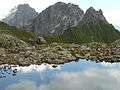 The Innsbrucker Hut with the Pinnisjoch and Kirchdachspitze behind