Interstate 471
| |||||||
|---|---|---|---|---|---|---|---|
.svg.png) | |||||||
| Route information | |||||||
| Auxiliary route of I‑71 | |||||||
| Maintained by Kentucky Transportation Cabinet and Ohio DOT | |||||||
| Length: | 5.75 mi[1] (9.25 km) | ||||||
| Existed: | 1981 – present | ||||||
| Major junctions | |||||||
| South end: |
| ||||||
|
| |||||||
| North end: |
| ||||||
| Highway system | |||||||
| |||||||

Interstate 471 (I-471) is a 5.75-mile-long (9.25 km) United States Interstate Highway, linking Interstate 71 in downtown Cincinnati, Ohio to Interstate 275 in Highland Heights, Kentucky. South of I-275, the expressway continues south to U.S. Route 27 as unsigned Kentucky Route 471.
Route description
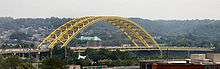
The southern terminus of I–471 is at an interchange with I–275 and US 27. I–471 heads northwest, then turns northeast having an interchange with US 27 in Southgate. After US 27, I–471 turns back northwest heading towards Cincinnati. On the way to Cincinnati, I–471 passes through the east side of Newport. On the east side of Newport, I–471 has an interchange with Kentucky Route 8 (KY 8). I–471 crosses the Ohio River using the Daniel Carter Beard Bridge, a Cincinnati landmark. After the Ohio River crossing, I–471 has an interchange with U.S. Route 50. After the interchange with US 50, I–471 has an interchange with I–71 northwest of downtown Cincinnati. The northern terminus of I–471 is at the interchange with I–71.[2]
History
Interstate 471 was first envisioned in 1961 as an east-west connector between Interstate 71/Interstate 75 in Covington with Interstate 71 in Cincinnati, crossing the Ohio River at a spot close to the current location. In effect, this connection would have provided for an alternative to Interstate 71, creating an inner loop system that would span both Ohio and Kentucky. Since this freeway would have hugged the southern riverfront, Interstate 471 would have prevented access to the Ohio River from Kentucky.
By 1967, the freeway was planned for a new alignment, much like the one seen today, connecting Cincinnati with Newport, Kentucky. On December 10, 1967, plans called for a north-south, 4.8-mile freeway that would connect Interstate 71 with Interstate 275 near the interchange with U.S. 27. Interstate 471 would have three lanes in each direction (which has since been reworked into four lanes in each direction due to a construction project). The bridge between Newport and Cincinnati was constructed between November 1971 and September 1976 and named Daniel Carter Beard after the founder of the Boy Scouts. Interestingly enough, it earned the nickname the "Big Mac Bridge" because its massive arches over the river resemble the golden arches of McDonald's restaurants. The Daniel Carter Beard Bridge was fully dedicated in 1981.
Subsequent construction extended the freeway south from the bridge in phases, with the last segment of Interstate 471 opening in 1980 at its junction with U.S. 27 south of Interstate 275. In 1981, the cost to construct the freeway and bridge was calculated to be $85 million.
Exit list
| State | County | Location | mi[3] | km | Exit | Destinations | Notes |
|---|---|---|---|---|---|---|---|
| Kentucky | Campbell | Highland Heights | 0.000 | 0.000 | 1 | Southern terminus and signed as exits 1A (east) and 1B (west);Highway continues south as KY 471; I-275 exits 74A-B | |
| Southgate | 1.745 | 2.808 | 2 | ||||
| Woodlawn | 3.202 | 5.153 | 3 | ||||
| 3.858 | 6.209 | 4 | |||||
| Newport | 4.649 | 7.482 | 5 | ||||
| Ohio River | 5.016 | 8.072 | Daniel Carter Beard Bridge | ||||
| Ohio | Hamilton | Cincinnati | 5.3 | 8.5 | 6A | Northbound exit and southbound entrance | |
| 5.4 | 8.7 | 6B | Sixth Street – Downtown | Northbound exit only | |||
| 5.6 | 9.0 | 7 | Liberty Street | Northbound exit and southbound entrance | |||
| 5.75 | 9.25 | — | Northbound exit and southbound entrance; northern terminus; I-71 exit 1D | ||||
| 1.000 mi = 1.609 km; 1.000 km = 0.621 mi | |||||||
References
- ↑ "Route Log and Finder List". FHWA. Retrieved 2007-06-01.
- ↑ Google (December 20, 2011). "Overview of I–471 in Kentucky and Ohio" (Map). Google Maps. Google. Retrieved December 20, 2011.
- ↑ "Kentucky Transportation Cabinet - Division of Planning - Highway Information System Official Milepoint Route Log Extract". Retrieved 2007-06-01.