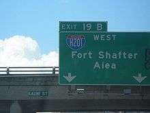
Interstate H-201
| |||||||
|---|---|---|---|---|---|---|---|
| Moanalua Freeway | |||||||
 | |||||||
| Route information | |||||||
| Maintained by HDOT | |||||||
| Length: | 4.10 mi[1] (6.60 km) | ||||||
| Existed: | 1989 – present | ||||||
| History: | Signed in 2004 | ||||||
| Major junctions | |||||||
| West end: |
| ||||||
|
| |||||||
| East end: |
| ||||||
| Highway system | |||||||
| |||||||

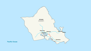
Interstate H-201 (H-201) is the only auxiliary Interstate Highway located on the island of O‘ahu in the U.S. state of Hawaii. The H-201 designation is also known as the Moanalua Freeway. The 4.1-mile-long (6.6 km) loop route connects exits 13 and 19 on H-1, passing Fort Shafter, Tripler Army Medical Center, and Red Hill.
Despite being designated an Interstate in 1989, until mid-2004 the route was a unsigned Interstate, signed only as Route 78. The section of the Moanalua Freeway between Route 99 (Kamehameha Highway) and the western H-1 interchange remains designated as Route 78.
History
The length of H-201 was originally designated as Route 78.[2]
The Federal Highway Administration approved the addition of H-201 to the Interstate Highway System on November 1, 1989.[3] The Hawaii Department of Transportation (HDOT) asked that the Moanalua Freeway be reclassified as an Interstate so that the interchange with H-1 at the eastern end could conform to federal highway standards. HDOT originally asked the American Association of State Highway and Transportation Officials (AASHTO) in June 1990 to approve the freeway as H-1A in an application to AASHTO's Special Committee on U.S. Route Numbering, the committee which approves Interstate Highway designations.[4] HDOT resubmitted a request later that year to number it as H-101, and AASHTO approved it as H-201 on December 8, 1990.[5] The highway was initially designated H-1A, but AASHTO policy does not generally allow alphabetic suffixes in Interstate numbers.[6] The final designation, H-201, conforms to the general rule for three-digit Interstate loop routes that uses an even initial digit.[5]
Until 2004, the state Department of Transportation chose not to sign H-201 as such, instead retaining the designation Route 78. Reasons given included the following:
- inability to render the new route number in a legible manner (it is necessary to use the thinnest font to render the number, and the shield is wider than the standard Interstate shield)
- encouraging motorists to use the newer and better designed H-1
- avoiding confusion with Interstate H-2[3]
In July 2004, in conjunction with a major resurfacing of both sides of the freeway, it was decided to bring the signage in line with the official designation.[3]
Exit list
The entire route is in Honolulu County.
| Location | mi | km | Exit | Destinations | Notes |
|---|---|---|---|---|---|
| Aiea | 0.0 | 0.0 | — | Western terminus | |
| Halawa | 0.5 | 0.80 | 1A | Transition point in signage between Route 78 and H-201; no eastbound exit; H-1 exit 13 | |
| 0.9 | 1.4 | 1B | Kahuapaani Street – Halawa, Camp Smith | Signed as exit 1E westbound | |
| | 1.4 | 2.3 | 1C | Signed as exit 1D westbound; H-3 west exit 1B | |
| Honolulu | 2.4 | 3.9 | 2 | Moanalua Valley, Salt Lake, Aiea | |
| 3.7 | 6.0 | 3 | |||
| 4.5 | 7.2 | 4 | Ahua Street – Fort Shafter | No number designation on exit | |
| 4.6 | 7.4 | — | Eastbound exit and westbound entrance; eastern terminus; H-1 west exit 19B | ||
1.000 mi = 1.609 km; 1.000 km = 0.621 mi
| |||||
See also
 Hawaii portal
 U.S. Roads portal
References
- ↑ Adderly, Kevin (December 31, 2014). "Table 2: Auxiliary Routes of the Dwight D. Eisenhower National System of Interstate and Defense Highways as of December 31, 2014". Route Log and Finder List. Federal Highway Administration. Retrieved June 8, 2015.
- ↑ Rand McNally (1989). "Hawaii" (Map). Rand McNally Road Atlas: United States/Canada/Mexico. Scale not given. Chicago: Rand McNally. p. 5. Oahu inset. OCLC 19224098. Retrieved September 9, 2007 – via Broer Map Library.
- 1 2 3 Watanabe, June (July 27, 2004). "Kokua Line: Moanalua is actually part of interstate". Honolulu Star-Bulletin. Retrieved August 7, 2016.
- ↑ Menhini, Leno (June 4, 1990). "Report of the Special Committee on U.S. Route Numbering to the Executive Committee" (PDF) (Report). Wilmington, DE: American Association of State Highway and Transportation Officials. Retrieved June 8, 2015.
- 1 2 Tabb, John R. (December 8, 1990). "Report of the Special Committee on U.S. Route Numbering to the Executive Committee" (PDF) (Report). Phoenix, AZ: American Association of State Highway and Transportation Officials. Retrieved June 8, 2015.
- ↑ American Association of State Highway and Transportation Officials (January 2000) [Retained from August 10, 1973]. "HO2: Establishment of a Marking System of the Routes Comprising the National System of Interstate and Defense Highways" (PDF). AASHTO Transportation Policy Book. American Association of State Highway and Transportation Officials. Retrieved June 8, 2015.
External links
- Photos of Interstate H-201 at Hawaii Highways
- Exit list for Interstate H-201 at Hawaii Highways