Iowa Highway 128
| ||||
|---|---|---|---|---|
 | ||||
| Route information | ||||
| Maintained by Iowa DOT | ||||
| Length: | 6.982 mi[1] (11.236 km) | |||
| Existed: | 1924 – present | |||
| Major junctions | ||||
| West end: |
| |||
| East end: |
| |||
| Location | ||||
| Counties: | Clayton | |||
| Highway system | ||||
| ||||

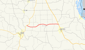
Iowa Highway 128 is a state highway entirely within Clayton County, in northeastern Iowa. It begins at Iowa 13 northeast of Elkader and ends at U.S. Highway 52 (US 52) north of Garnavillo. The highway was originally part of Iowa 56 before becoming its own route. Iowa 128's route remains the same as when it was first designated.
Route description
Iowa 128 begins a T-intersection with Iowa 13 two miles (3.2 km) north of Elkader. It passes through rolling farmland on the western edge of the Driftless Area, a geologically distinct area of northeastern Iowa characterized by undulating terrain, high bluffs, and low river valleys.[2] It travels nearly seven miles (11 km) to the east until it ends at an intersection with US 52 one mile (1.6 km) north of Garnavillo.[1]
History
When the primary highway system was created in 1920, what is now Iowa 128 was designated as a part of Primary Road No. 56 (No. 56). That road began in West Union and traveled east to Elkader, where it was joined by No. 10 / No. 13. The three routes shared two miles (3.2 km) before No. 56 split away to the east. It then joined No. 20 and headed southeast to its eastern end in Guttenberg.[3] In 1924, No. 56 was shortened to end at No. 10 / No. 13 in Elkader. The overlappings along No. 10 / No. 13 and No. 20 were removed and the remaining standalone section became No. 128.[4]
Major intersections
The entire route is in Clayton County.
| Location | mi[1] | km | Destinations | Notes | |
|---|---|---|---|---|---|
| Boardman Township | 0.000 | 0.000 | |||
| Garnavillo Township | 6.982 | 11.236 | |||
| 1.000 mi = 1.609 km; 1.000 km = 0.621 mi | |||||
References
- 1 2 3 "2012 Volume of Traffic on the Primary Road System of Iowa" (PDF). Iowa Department of Transportation. January 1, 2012. Retrieved February 8, 2014.
- ↑ Iowa State University Geographic Information Systems Support & Research Facility. "Iowa Geographic Map Server". Retrieved December 15, 2009.
- ↑ Iowa State Highway Commission (1919). Iowa State Highway Map (PDF) (Map). Ames: Iowa State Highway Commission. Retrieved February 9, 2014.
- ↑ Iowa State Highway Commission (1925). Iowa State Highway Map (PDF) (Map). Ames: Iowa State Highway Commission. Retrieved February 9, 2014.