Iowa Highway 38
| ||||
|---|---|---|---|---|
 | ||||
| Route information | ||||
| Maintained by Iowa DOT | ||||
| Length: | 98.941 mi[1] (159.230 km) | |||
| Existed: | 1920[2] – present | |||
| Major junctions | ||||
| South end: |
| |||
| North end: |
| |||
| Location | ||||
| Counties: | ||||
| Highway system | ||||
| ||||

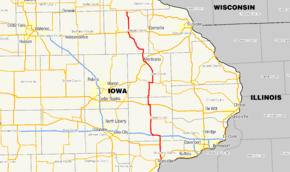
Iowa Highway 38 is a 98-mile-long (158 km) state highway that runs through eastern Iowa. Iowa 38 begins at Iowa Highway 92 in Muscatine and ends at Iowa Highway 3 near Greeley.
Route description
Iowa 38 begins in Muscatine at an intersection with Iowa 92 at the foot of the Norbert F. Beckey Bridge. Southwest of the junction, U.S. Highway 61 Business (US 61 Business) heads into the downtown and riverfront areas, while northeast of the junction, US 61 Business, Iowa 38, and Iowa 92 run together through a residential area. Shortly thereafter, Iowa 22 joins the two routes from the east. The intersection with U.S. Highway 61 (US 61) in northern Muscatine marks the end of US 61 Bus. Iowa 22 and Iowa 92 turn to the west along southbound US 61.[3]
From Muscatine, Iowa 38 continues north eight miles (13 km) to the southern intersection with US 6 south of Wilton. Just north of Wilton, US 6 / Iowa 38 cross into Cedar County. Shortly thereafter, they intersect Interstate 80 (I-80) and split in opposite directions; US 6 splits to the east and Iowa 38 to the west. Iowa 38 overlaps I-80 from exit 267 to exit 271. From I-80, the highway continues north towards Tipton where it meets the western end of Iowa 130. North of Tipton, Iowa 38 overlaps US 30 for one mile (1.6 km), ending in Stanwood where Iowa 38 continues north.
Iowa 38 enters Jones County south of Olin and crosses the Wapsipinicon River on Olin's northern edge. Four miles (6.4 km) later, Iowa 38 intersects Iowa 64, which Iowa 38 overlaps for two miles (3.2 km) before heading north towards Monticello passing through Center Junction and Scotch Grove. Next to the Monticello Regional Airport, Iowa 38 meets US 151. Three-quarters mile (1.2 km) later, Iowa 38 meets and overlaps the former alignment of US 151, now US 151 Business. At First Street, it leaves US 151 Bus to the west for a few blocks before turning north again towards Hopkinton and crossing the Maquoketa River.
Just north of Sand Springs, Iowa 38 intersects County Road X47 (CR X47), which is a cutoff to eastbound US 20. From Hopkinton to Delhi, the highway is roughly parallel to the Maquoketa River. At Delaware, Iowa 38 intersects US 20. Iowa 38 briefly overlaps US 20's former routing, now CR D22, north of Delaware. Iowa 38 continues north through Greeley and ends three miles (4.8 km) north of Greeley at Iowa 3.
Major intersections
| County | Location | mi[1] | km | Destinations | Notes |
|---|---|---|---|---|---|
| Muscatine | Muscatine | 0.000 | 0.000 | Southern end of US 61 Business and Iowa 92 overlaps | |
| 0.717 | 1.154 | Southern end of Iowa 22 overlap | |||
| 1.985 | 3.195 | End of US 61 Business; northern end of Iowa 22 and Iowa 92 overlaps | |||
| Moscow–Wilton township line | 9.851 | 15.854 | Southern end of US 6 overlap | ||
| Cedar | Sugar Creek Township | 14.753 | 23.743 | Northern end of US 6 overlap; southern end of I-80 overlap | |
| Rochester Township | 18.892 | 30.404 | Northern end of I-80 overlap | ||
| Tipton | 28.169 | 45.334 | |||
| Fremont–Dayton township line | 36.271 | 58.373 | Southern end of US 30 overlap | ||
| Stanwood | 37.287 | 60.008 | Northern end of US 30 overlap | ||
| Jones | Jackson Township | 50.046 | 80.541 | Southern end of Iowa 64 overlap | |
| Madison Township | 52.053 | 83.771 | Northern end of Iowa 64 overlap | ||
| Monticello | 65.030 | 104.656 | |||
| 65.820 | 105.927 | Southern end of US 151 Business overlap | |||
| 66.098 | 106.374 | Northern end of US 151 Business overlap | |||
| Delaware | Delaware | 87.387 | 140.636 | ||
| Elk Township | 98.941 | 159.230 | |||
1.000 mi = 1.609 km; 1.000 km = 0.621 mi
| |||||
References
- 1 2 "2010 Volume of Traffic on the Primary Road System of Iowa" (PDF). Iowa Department of Transportation. January 1, 2010. Retrieved January 21, 2011.
- ↑ Iowa State Highway Commission (1919). Iowa State Highway Map (PDF) (Map). Ames: Iowa State Highway Commission. Retrieved July 31, 2013.
- ↑ Iowa Department of Transportation (2013). Iowa State Highway Map (PDF) (Map). Ames: Iowa Department of Transportation. Muscatine inset. Retrieved July 13, 2013.
External links
- End of Iowa 38 at Iowa Highway Ends