Island Eastern Corridor
| |
|---|---|
| Part of Route 4 | |
|
IEC coloured red | |
| Route information | |
| Maintained by Highways Department | |
| History: |
1984 (Phase I) 1985 (Phase II) 1989 (Phase III) |
| Major junctions | |
| East end: | Chai Wan |
| West end: | Causeway Bay |
| Location | |
| Districts: | Eastern, Wan Chai |
| Highway system | |
| Hong Kong Strategic Route and Exit Number System | |


| Island Eastern Corridor | |||||||||||
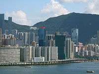
 The west end of Island Eastern Corridor at Causeway Bay | |||||||||||
| Traditional Chinese | 東區走廊 | ||||||||||
|---|---|---|---|---|---|---|---|---|---|---|---|
| Simplified Chinese | 东区走廊 | ||||||||||
| |||||||||||
.jpg)

Island Eastern Corridor (IEC) is an expressway built along the northeastern shore of Hong Kong Island in Hong Kong. It starts from Causeway Bay in the west and ends in Chai Wan in the east. It is part of Route 4. The section between Causeway Bay and Quarry Bay consists mainly of viaducts built along Victoria Harbour.
History
After World War II, the Eastern District of Hong Kong Island developed rapidly. As a result, the major thoroughfare in the area, King's Road, became very congested.[1]
To relieve the congestion problem, the idea of constructing the corridor was brought out in 1968. However, commencement of construction did not begin until 8 April 1981, 20 May 1982 and 5 August 1986.[2] The corridor was opened in three phases: Causeway Bay to Tai Koo Shing on 8 June 1984; Tai Koo Shing to Shau Kei Wan on 26 July 1985; and Shau Kei Wan to Chai Wan on 12 October 1989.[1]
Work has been done to the expressway several times over its life, including the bridge diversions at Quarry Bay, completed in 2003, where Route 4 joins with Route 2. There is also a proposed extension of the Corridor into the hills of Chai Wan and Siu Sai Wan.
The Government has also proposed the Central-Wan Chai Bypass, which eastern end will connect to the Island Eastern Corridor.[3]
In 2008 the Island Eastern Corridor became the new venue of the Hong Kong Marathon 10km race, held on 2008-02-17. The race track started from City Garden in North Point, and ran eastwards until Shau Kei Wan, where it made a U-turn, back along westbound IEC and ended at Victoria Park, near the western terminus of the IEC. The noise problem caused by the IEC's design became evident as residents complained about noises as high as 60dB emitting at about five to six o'clock in the morning.[4][5]
In February 2008 the Government announced that it will construct a waterfront promenade between Causeway Bay and Sai Wan Ho, with significant sections at North Point running under Island Eastern Corridor, using floating boards. However, the Government is concerned about the plan violating the Protection of the Harbour Ordinance, since the boards may need to extend seabound due to the lack of space. Further study will take place regarding the feasibility of the project. When it is finished, a continuous promenade will be formed between Central and Sai Wan Ho, together with recreational land use projects related to the Central-Wan Chai Bypass.[6]
Alignment
The corridor starts at Causeway Bay as a viaduct, where it joins Victoria Park Road and Gloucester Road with a ramp. It then heads east along the coast of North Point, still a viaduct until it comes to Quarry Bay where it descends onto ground level, and interchanges with the approach road of Eastern Harbour Crossing. After it has passed Tai Koo Shing, it becomes a viaduct again, now crossing between Sai Wan Ho and Aldrich Bay, making a broad curve toward the Hong Kong Museum of Coastal Defence, where it returns to ground level and runs past A Kung Ngam and Heng Fa Chuen all the way towards Chai Wan. It ends near Chai Wan Park,at a large roundabout with Chai Wan Road and Wan Tsui Road in Chai Wan, just next to MTR Chai Wan Station.
The speed limit for the IEC expressway is 70 km/h.
Criticism
It is often criticised for using up the seafront which could have been enjoyed by residents of Hong Kong had alternative alignments been chosen. Residents have also complained about traffic noises owing to some sections' proximity to residential buildings, and it could be advised that there would have to be sound barriers installed along this section. It has been suggested that the Watson Road – Tin Chiu Street section of the corridor be replaced with a tunnel, but was never considered due to the complex nature of the necessary works.[7]
Bus routes using the Corridor
The bus companies in Hong Kong operate a number of "express" bus routes that travel on the Island Eastern Corridor. Examples are:
- KMB (Jointly operated with Citybus)
- New World First Bus
- 2X Wan Chai Ferry Pier <-> Aldrich Bay
- 8 Wan Chai Ferry Pier <-> Heng Fa Chuen
- 8P Wan Chai Ferry Pier <-> Siu Sai Wan (Island Resort)
- 720 Central (Macau Ferry Terminal) <-> Aldrich Bay
- 720A Aldrich Bay <-> Admiralty (circular)
- 720P Central (Macau Ferry Terminal) <-> Taikoo Shing (circular)
- 722 Yiu Tung Estate <-> Central (Exchange Square) (circular)
- Citybus
- 8X Happy Valley (Lower) <-> Siu Sai Wan (Island Resort)
- 780 Chai Wan (East) <-> Central (Ferry Piers)
- 788 Central (Macau Ferry Terminal) <-> Siu Sai Wan (Island Resort)
- 789 Siu Sai Wan (Island Resort) <-> Admiralty (Rodney Street)
Junctions along the Corridor
The junctions along the corridor are as follows:
| Road | For | Access | Exit Number (Route 4) |
|---|---|---|---|
| Hing Fat Street | Causeway Bay | Limited access:
|
6B |
| Tong Shui Road | North Point | Limited access:
|
6A |
| Man Hong Street | North Point/Quarry Bay | Full access | 6 |
| Eastern Harbour Crossing (Route 2) | Kowloon East | Full access | 5 |
| Tai Koo Wan Road | Tai Koo Shing | Full access | 4 |
| Hong On Street/Tai Hong Street | Kornhill/Sai Wan Ho | Limited access:
|
3C |
| Nam On Street | Shau Kei Wan/Aldrich Bay | Limited access:
|
3B |
| Chai Wan Road | Shek O and Stanley | Limited access:
|
3A |
| Nam On Street | Shau Kei Wan | Limited access:
|
2B |
| Tung Hei Road | Aldrich Bay | Limited access:
|
2A |
| Shing Tai Road/Wing Tai Road | Siu Sai Wan and Heng Fa Chuen | Full access
|
2 |
| Lee Chung Street | Chai Wan | Limited access
|
1 |
See also
References
- 1 2 Roads and Railways – Hong Kong Trunk Routes 1(中文)
- ↑ Maunsell Consultants Asia Ltd Project Information Sheet – Island Eastern Corridor, Hong Kong
- ↑ Housing, Planning and Land's Bureau. "Fact Sheet: Engineering aspects (Central and Wan Chai Reclamation)".
- ↑ "New Route for 2008 Standard Chartered Hong Kong Marathon". ASIATravelTips.com.
- ↑ "馬拉松噪音超標居民投訴". Ming Pao. 18 February 2008.
- ↑ "海濱長廊擬中環直達北角". Ming Pao. 21 February 2008.
- ↑ LCQ17: Suggestion of replacing parts of Island Eastern Corridor with a tunnel
External links
| Wikimedia Commons has media related to Island Eastern Corridor. |
| Preceded by Eastern Terminus |
Hong Kong Route 4 Island Eastern Corridor |
Succeeded by Victoria Park Road |
Coordinates: 22°17′37″N 114°11′57″E / 22.293547°N 114.199097°E