Iturup
| Disputed island Other names: Russian: Итуру́п; Japanese: 択捉島; Ainu:エツ゚ヲロプシㇼ | |
|---|---|
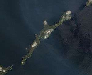 | |
| NASA picture of Iturup's southern end with volcano Berutarube and small clouds | |
| Geography | |
 | |
| Location | Sea of Okhotsk |
| Coordinates | 45°02′N 147°37′E / 45.033°N 147.617°ECoordinates: 45°02′N 147°37′E / 45.033°N 147.617°E |
| Archipelago | Kuril Islands |
| Area | 3,139 square kilometres (776,000 acres) |
| Length | 200 kilometres (120 mi) |
| Width | 27 kilometres (17 mi) |
| Highest point | Stokap 1,634 metres (5,361 ft) |
| Administered by | |
| Russia | |
| Oblast | Sakhalin |
| Claimed by | |
| Japan | |
| Prefecture | Hokkaido |
| Russia | |
| Oblast | Sakhalin |
| Demographics | |
| Population | 7,500 (as of 2003) |
Iturup (Russian: Итуру́п and Oстров Итуру́п, Ostrov Iturup[1]; Ainu: エツ゚ヲロプシㇼ, Etuworop-sir; Japanese: 択捉島, Etorofu-tō[2]) is one of the Kuril Islands. It was formerly known as Staten Island.[3] It is the largest and northernmost island in the southern Kurils, which are disputed between Japan and Russia.
The island was Japanese territory until the end of the Second World War in 1945, when Soviet forces took possession of all the Kurils and forced out Japanese residents. The island is still claimed by Japan (see Kuril Islands dispute). Japan considers a site on Iturup to be its northernmost point.
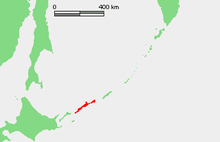
Iturup is located near the southern end of the Kuril chain, between Kunashiri (19 km to the SW) and Urup (37 km to the NE). The town of Kurilsk, administrative center of Kurilsky District, is located roughly midway along its western shore.
- Area – 3,139 km²
- Length – 200 km
- Width – 7–27 km
The strait between Iturup and Urup is known as the Vries Strait, after Dutch explorer Maarten Gerritsz Vries, the first recorded European to explore the area.[4]
Geography
Iturup consists of volcanic massifs and mountain ridges. A series of a dozen volcanoes running NE to SW form the backbone of the island, the highest being Stokap (1,634 m) in the central part of Iturup. The shores of the island are high and abrupt. The vegetation mostly consists of spruce, larch, pine, fir, and mixed deciduous forests with alder, lianas and Kuril bamboo underbrush. The mountains are covered with birch and Siberian Dwarf Pine scrub, herbaceous flowers (including Fragaria iturupensis, the Iturup strawberry) or bare rocks.
The island also contains some of high waterfalls, such as the Ilya Muromets.
Rheniite, a rhenium sulfide mineral (ReS2), was discovered at the Kudriavy volcano[5] and approved in 2004. It is found in active hot fumaroles on the volcano.
History
Initially inhabited by the Ainu, Iturup was reached in 1661 by the Japanese Shichirobei and his fellows after they had drifted there. The island saw both a Russian settlement (late 18th century) and a Japanese garrison (1800) at the site of the present-day Kurilsk. In 1855 Iturup was ceded to Japan by the Treaty of Shimoda. Its name comes from the Ainu エツ゚ヲロプ (Etuworop), meaning "Place possessing [many] capes."
On 26 November 1941, a Japanese carrier fleet left Hitokappu Bay (now called Kasatka Bay[6]), on the eastern shore of Iturup, and sailed for an attack on the American base of Pearl Harbor.
In 1945, according to decisions of the Yalta Conference, it was occupied by the Soviet Union after Japan's defeat in World War II. The Japanese inhabitants were expelled to mainland Japan.[7] In 1956 the two countries agreed to restore diplomatic relations, but the peace treaty, as of 2016, has not been concluded due to the disputed status of Iturup and some other nearby islands.
A Soviet Anti-Air Defense (PVO) airfield, Burevestnik (English: storm-petrel), is located on the island and since the 1950s has been home for a number of Mikoyan fighter jets. In 1968, Seaboard World Airlines Flight 253A was intercepted over the Kurils and forced to land at Burevestnik with 214 American troops bound for Vietnam. An older airfield, Vetrovoe, exists on the eastern part of the island and may have been used primarily by Japanese forces during World War II.
Administratively this island belongs to the Sakhalin Oblast of the Russian Federation. A new international airport was opened on the island in September 2014.[8]
Sport
There are plans for a friendly bandy match between Sakhalin and the Japanese national team.
Media about Iturup
- Iturup
 Volcanoes of Iturup
 Rheniite, hardened lava on the backside, from the Kudriavy Volcano
 Japanese inhabitants of the island at a riverside picnic in 1933
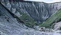 Iturup, 1981
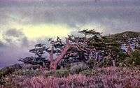 Trees under permanent wind, 1981
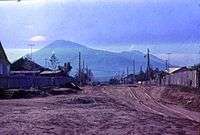 Kurilsk, 1981
See also
References
- ↑ "Ostrov Iturup: Russia". Geographical Names. Retrieved 2014-02-24.
- ↑ "Etorofu-tō: Russia". Geographical Names. Retrieved 2014-02-24.
- ↑ Heawood, Edward (1912). A history of geographical discovery in the seventeenth and eighteenth centuries. Cambridge: Cambridge University Press. p. 87.
- ↑ Dutch exploration
- ↑ Korzhinsky, M.A.; S. I. Tkachenko; K. I. Shmulovich; Y. A. Taran; G. S. Steinberg (2004-05-05). "Discovery of a pure rhenium mineral at Kudriavy volcano". Nature. 369 (6475): 51–52. Bibcode:1994Natur.369...51K. doi:10.1038/369051a0.
- ↑ Внешняя политика Японии: сентябрь 1939 г.-декабрь 1941 г – 1959, page 246 (Russian)
- ↑ Takahara, "Nemuro raid survivor"
- ↑ "New airport opens on South Kurils' Iturup Island". ITAR TASS. Retrieved 26 October 2014.
External links
- Takahara, Kanako (September 22, 2007). "Nemuro raid survivor longs for homeland" (Newspaper article). Japan Times. Retrieved 2008-02-01.
- Google Maps
- Ocean Dots.com at the Wayback Machine (archived December 23, 2010)
- Sakhalin Oblast