Jümme (river)
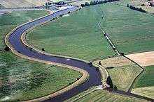 | |
| Aerial photograph of the Jümme | |
| Location | Lower Saxony, |
|---|---|
| Length | 19 km [1] |
| Source | Confluence of the Soeste and the Dreyschloot, west of Barßel 53°10′54″N 7°41′13″E / 53.1815763°N 7.6869795°ECoordinates: 53°10′54″N 7°41′13″E / 53.1815763°N 7.6869795°E |
| Source height | < 2 m above sea level (NN) |
| Mouth | East of Leer into the Leda 53°13′24″N 7°31′29″E / 53.2234278°N 7.5246764°E |
| Mouth height | < 1 m above sea level (NN) |
| Descent | ca. 1 m |
| Basin | Ems |
| Progression | Leda → Ems → North Sea |
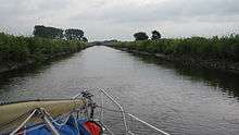
The Jümme is a tributary of the Leda in northern Germany. Its headwaters are the Aper Tief, which flows from the Oldenburg geest, and the Soeste. The Jümme is 18 kilometres (11 mi) long from its headstream, the Aper Tief, to its confluence with the Leda near Wiltshausen and is tidal. Fishing rights rest with the local fishing club, Fischereiverein Altes Amt Stickhausen, which issues fishing permits to its members and to visiting anglers.
The Jümme gives its name to the collective municipality of Jümme.
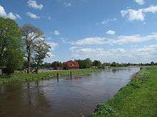
Together with the Leda the Jümme forms the so-called Zweistromland or "Two Rivers Land", the Leda-Jümme region, one of the most charming areas in East Frisia, with its numerous lakes such as the Jümmesee which covers an area of 11 hectares (27 acres).