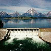
Jackson Lake Dam
| Jackson Lake Dam | |
|---|---|
 Jackson Lake Dam in June 1997 as seen looking upstream/west from the north shore of the Snake River. | |
 Location of Jackson Lake Dam in Wyoming | |
| Location | Teton County, Wyoming, in Grand Teton National Park |
| Coordinates | 43°51′27.53″N 110°35′22.54″W / 43.8576472°N 110.5895944°WCoordinates: 43°51′27.53″N 110°35′22.54″W / 43.8576472°N 110.5895944°W |
| Construction began | 1911 |
| Opening date | 1916 |
| Operator(s) | U.S. Bureau of Reclamation |
| Dam and spillways | |
| Type of dam | Concrete gravity with earth embankment wings |
| Impounds | Snake River |
| Height | 65 ft (20 m) |
| Length | 4,920 ft (1,500 m) |
| Width (crest) | 24 ft (7.3 m) |
| Width (base) | 72 ft (22 m) |
| Spillway type | gated overflow |
| Spillway capacity | 8690cfs at 6790 ft |
| Reservoir | |
| Creates | Jackson Lake |
| Total capacity | 847,000 acre feet (1.045 km3) |
| Catchment area | 1,824 sq mi (4,720 km2) |
 | |
Jackson Lake Dam is a concrete and earth-fill dam at the outlet of Jackson Lake in northwestern Wyoming, USA. The lake and dam are situated within Grand Teton National Park in Teton County. The Snake River emerges from the dam and flows about 800 miles (1,287 km) through Wyoming, Idaho, Oregon, and Washington to its mouth on the Columbia River in eastern Washington. The chief purpose of the dam is to provide water storage for irrigation in the Snake River basin in the state of Idaho as part of the Minidoka Project. Jackson Lake is a natural lake but its depth was increased by the dam to provide water storage.
History
The first Jackson Lake Dam was a log-crib dam constructed in 1906-7 across the outlet of Jackson Lake, a natural lake. That dam raised the lake level by 22 feet (6.7 m), but the dam failed in 1910. A new concrete and earthen dam was constructed in stages between 1911 and 1916, raising the maximum lake level to 30 feet (9.1 m) above the lake's natural elevation, providing a storage capacity of 847,000 acre feet (1.045×10⁹ m3).[1] The new dam was designed by Frank A. Banks, who would later supervise the construction of Grand Coulee Dam.[2]
The reservoir was created by damming the outlet of the natural glacial Jackson Lake, with the additional height creating a storage pool for the Minidoka Project, which provides irrigation water from the Snake River for farmlands in Idaho. Jackson Lake stores and releases water which is collected by Minidoka Dam and American Falls Dam more than 100 miles (160 km) downstream for diversion to distribution canals.[1][3] At the time of the dam's construction, Jackson Hole and the Teton Range were as yet unprotected from development. Grand Teton National Park was established in 1929, and excluded Jackson Lake. The lake was incorporated into Jackson Hole National Monument when it was proclaimed by President Franklin D. Roosevelt under the Antiquities Act, and became a part of Grand Teton National Park in 1950 when the park was expanded to encompass the national monument lands. When the dam was built there was no attempt to clear the shores of the lake of standing timber, resulting in an unsightly band of dead trees when the waters rose. This vista, and the mudflats created by drawdown of lake waters, were cited in later years in successful arguments against reservoirs in Yellowstone National Park.[4][5]
Construction personnel for the dam were housed at a temporary camp that dwarfed the nearby town of Moran, Wyoming. Supplies came in from the Grassy Lake Road north of the park, which runs west into Idaho to meet the nearest railhead at Ashton, Idaho.[6]
Reinforcement
The U.S. Bureau of Reclamation conducted studies on dams in 1976 and determined that Jackson Lake Dam was susceptible to failure in case of an earthquake of magnitude 5.5 or greater. The dam was upgraded during 1986-1989, and the Bureau of Reclamation believed it could withstand the "maximum credible earthquake," a magnitude 7.5 quake on the Teton fault. Since then various studies have cast doubt on this belief.[7][8][9][10][11][12]
Dam facts and figures
The dam is owned and operated by the U.S. Bureau of Reclamation, which maintains the water level above the lake’s natural elevation for downstream irrigation.
- Type: Concrete gravity dam with earthen embankment wings
- Drainage area: 1,824 square miles (4,724 km2)
- Lake elevation:
- Normal full pool: 6,760 feet (2,060.4 m)
- Maximum pool: 6,769 feet (2,063.2 m)
- Minimum pool: 6,730 feet (2,051.3 m)
- Maximum water surface: 6,770.3 feet (2,063.6 m)
- Usable storage (6730–6760 ft): 847,000 acre feet (1.045×10⁹ m3)
- Crest elevation: 6,777 feet (2,065.6 m)
- Crest length: 4,920 feet (1,499.6 m)
- Crest width: 24 feet (7.3 m)
- Base width: 72 feet (21.9 m)
- Structural height: 65 feet (19.8 m)
 Jackson Lake Dam. View is to the west.
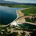 Jackson Lake Dam. View is to the northwest.
See also
References
- 1 2 "Minidoka Project". U.S. Bureau of Reclamation. Retrieved 3 May 2011.
- ↑ The United Press. Builder of Grand Coulee To Retire and Live Near It. The New York Times, September 12, 1950.
- ↑ Stene, Eric A. (1997). "The Minidoka Project" (PDF). U.S. Bureau of Reclamation.
- ↑ Haines, Aubrey L. (1996). The Yellowstone Story: A History of Our First National Park. University Press of Colorado. p. 346. ISBN 0-87081-390-0.
- ↑ Yochim, Michael J. "Conservationists and the Battles to Keep Dams Out of Yellowstone: Hetch Hetchy Overturned" (PDF): 299.
- ↑ "Chapter 13: The Communities of Jackson Hole". A Place Called Jackson Hole: A Historic Resource Study of Grand Teton National Park. National Park Service. 2008-08-12. Retrieved April 19, 2011.
- ↑ Angus M. Thuermer Jr. Science to settle dam debate Safety of Jackson Lake Dam is being reassessed as new technology comes to fore.
- ↑ Bureau of Reclamation 'Final Report Ground Motion Evaluation for Jackson Lake Dam Minidoka Project, Wyoming
- ↑ Casper Star Tribune New quake study rattles Jackson
- ↑ Tsuda, K.; Archuleta, R. J.; O'Connell, D. R.; Bonilla, F. L. Nonlinear Wave propagation at sediment layers
- ↑ Angus M. Thuermer Jr. County, feds fight over dam safety County says officials are hiding studies, muzzling scientists.
- ↑ O'Connell, D. R.; Graves, R. W.; Block, L. V. Strong Motion Prediction Within a Basin Located Above the Teton Fault in Wyoming
External links
- U.S. Bureau of Reclamation: Jackson Lake Dam
- U.S. Bureau of Reclamation: Minidoka Project
- University of Wyoming: The Operation and Management of Jackson Lake Dam
- U.S. Army Corps of Engineers: Jackson Lake Dam and Lake Hydrologic Data
- U.S. National Park Service: The Snake River: Responses to Jackson Lake Dam (PDF)