Jamestown Viaduct
| Jamestown Viaduct | |
|---|---|
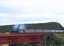 The Great Marquess crossing Jamestown Viaduct near the Inverkeithing terminus of the SRPS "Forth Circle" special service on 22 August 2010. | |
| Carries | Edinburgh to Aberdeen Line |
| Characteristics | |
| Material | Steel |
| Longest span | 33.4 metres (110 ft) |
| Number of spans | 2 stone arches, 4 steel spans |
| History | |
| Opened | 1890 |
The Jamestown Viaduct is part of the northern approach to the Forth Bridge in Scotland. It crosses the hamlet of Jamestown and the village of North Queensferry in Fife.
History

It was constructed between 1887 and 1890, and listed as a Grade B listed building in 2004.[1]
In 2005, the viaduct was strengthened during an eight-day closure of the railway.[2][3] 120 tonnes (120 long tons; 130 short tons) of steel and 600 cubic metres (21,000 cu ft) of high strength concrete were used to add a reinforced concrete slab underneath the track, in order to improve the load-carrying capacity to Network Rail's standards.[3] The work was worth around GB£5 million, and engineered by Corus and carried out by Mowlem.[4][5] 20,000 man-hours were worked during the period of closure, which coincided with a "possession" of the Forth Bridge.[2][3]
Design

It has four main steel girder spans, supported by three sandstone piers.[6] As well as the four steel spans, there is a stone arch at each end of the viaduct.[1] The steel spans are 33.4 metres (110 ft) long, and are at a skew of 70°[1] The spans consist of twin truss girders sitting on the piers, and on top of the truss cross-girders supporting steel deck plates, with a ballasted track.[1]
The viaduct carries the line crossing the Forth Bridge, from Edinburgh to Aberdeen and the north of Scotland, and carries a significant volume of both passenger and freight rail traffic, which previously included transporting coal to Longannet Power Station[1] prior to its closure in 2016. As of 2006 there were up to 200 train movements a day and loads of 27 million tonnes annually.[3]
It spans the B981 public road and the former branch railway to North Queensferry and Rosyth.[6] It runs close to and nearly parallel to the A90 road, but the viaduct has a slight curve to the east.[7]
References
- 1 2 3 4 5 Roberts, C.; Bell, G.; Hanson, A.; Henderson, D. (2007). "Jamestown Viaduct, UK: Strengthening of an early steel viaduct". Proceedings of the ICE - Bridge Engineering. 160 (2): 57–63. doi:10.1680/bren.2007.160.2.57.
- 1 2 "Bridge closure causes no problems". BBC News. 25 July 2005. Retrieved 9 September 2014.
- 1 2 3 4 "Jamestown Viaduct Inverkeithing, Fife". betterpublicbuilding.org.uk. Retrieved 9 September 2014.
- ↑ "Shear strength of slab". Railway Gazette. 1 October 2005. Retrieved 9 September 2014.
- ↑ "Winning Corus Design Grants Historic Viaduct a New Lease of Life" (Press release). Tata Steel. Retrieved 9 September 2014.
- 1 2 "Inverkeithing, Jamestown Viaduct". rcahms.gov.uk. Retrieved 9 September 2014.
- ↑ Google (9 September 2014). "Jamestown Viaduct" (Map). Google Maps. Google. Retrieved 9 September 2014.
External links
| Wikimedia Commons has media related to Jamestown Viaduct. |
Coordinates: 56°00′25″N 3°23′31″W / 56.007°N 3.392°W