Jenson Tunnel
 North Entrance of Jenson Tunnel | |
| Overview | |
|---|---|
| Other name(s) | KCS-Backbone Tunnel |
| Location | Le Flore County, Oklahoma |
| Coordinates | +35.21735, -94.44298 |
| Status | Active |
| Operation | |
| Work begun | 1885 |
| Opened | 1886 |
| Technical | |
| Length | 1180 |
| Track gauge | Standard |
| Lowest elevation | 600 feet |
| Tunnel clearance | 20.0 feet |
| Width | 14.0 feet |
Jenson Railroad Tunnel [lower-alpha 1][1] is the first and only railroad tunnel in the present state of Oklahoma. It was constructed through Backbone Mountain[lower-alpha 2] during 1885-6, by the Fort Smith & Southern Railway (FSSR).[lower-alpha 3] [3] and has remained in service until the present. At the time it was built, this area belonged to the Choctaw Nation in Indian Territory.[4] Since Oklahoma became a state in 1907, the tunnel site has been part of Le Flore County, Oklahoma. It is now primarily used by the Kansas City Southern Railroad (KCS), and is sometimes referred to as the KCS - Jenson Tunnel.[1]
History
Jenson Tunnel is located on private property northeast of Rock Island and is the only known railroad tunnel in Oklahoma. Now used by the Kansas City Southern, it was built by Frisco Railway in 1885-6.[lower-alpha 4] The tunnel was created through Backbone Mountain in what is now Le Flore County, Oklahoma.[1]
One blogger reported that the tunnel was built on the east side of the Arkansas-Indian Territory border, but that a subsequent realignment of the border put it entirely inside the present state of Oklahoma.[6]
Description
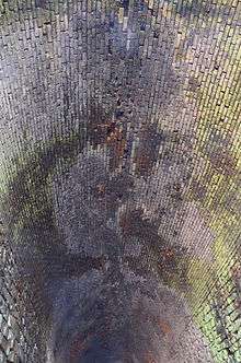
The tunnel is 1,180 feet (360 m) long and has a single track. The deck width is 14.0 feet (4.3 m) and the clearance above the deck is 20.0 feet (6.1 m). Its elevation is 600 feet (180 m) above mean sea level.[1] The tunnel has various lengths of lining and arching. 624 feet (190 m) of the interior is unlined and has no arching. About 324 feet (99 m) at each end are lined with stone and have a brick arch. 62 feet (19 m). The rest of the length (118 feet (36 m)) has timber posts and arches.[3]
NRHP listing
The tunnel was listed on the National Register of Historic Places (NRHP) on May 13, 1976. Reference number is 76001567.[1]
Notes
- ↑ Also called "KCS-Backbone Tunnel".
- ↑ Backbone Mountain is a feature of the Ouachita Mountain range and is also called Devil's Backbone. The mountain extends across the state line into Sebastian County, Arkansas. The Battle of Devil's Backbone was fought on this mountain on September 1, 1863, during the American Civil War.
- ↑ The St. Louis & San Francisco Railroad (also known as the "Frisco" or SLSF.) controlled the Fort Smith & Southern Railway, which was formed in 1886 and which was absorbed by the Frisco in March, 1887.[2]
- ↑ Stone markers above the north and south portals show a date of 1886.[5]
External links
- Map Showing Located Line of the Fort Smith Southern Railway, Through Part of Choctaw Nation, Indian Territory, Sugar Loaf County. NARA On-line Public Access. Retrieved April 2, 2015.
- "Frisco.org Forum." Blog discussing Jenson Tunnel. Retrieved April 2, 2015.
References
- 1 2 3 4 5 "KCS - Jenson Tunnel," Bridgehunter.com. 2008.Accessed March 22, 2015.
- ↑ "Ft. Smith Area Railroads - History Timeline." July 2007. Retrieved April 2, 2015.
- 1 2 Traci Coston Barnes."Oklahoma's First and Only Railroad Tunnel." Retrieved March 24, 2015.
- ↑ "National Register Properties in Oklahoma.- Jenson Tunnel." Accessed April 5, 2015.
- ↑ "Oklahoma Love Affair Blog, The Only Railroad Tunnel in Oklahoma." November 11, 2009. Accessed March 22, 2015.
- ↑ "Frisco.org" Post by tomd6. March 12, 2007. Retrieved April 2, 2015.