Jim Woodruff Dam
| Jim Woodruff Dam | |
|---|---|
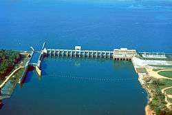 Aerial view of Jim Woodruff Dam in 1999 (by U.S. Army Corps of Engineers) | |
| Official name | Jim Woodruff Dam |
| Location | Gadsden and Jackson counties, Florida / Decatur County, Georgia, USA |
| Coordinates | 30°42′31″N 84°51′51″W / 30.70861°N 84.86417°WCoordinates: 30°42′31″N 84°51′51″W / 30.70861°N 84.86417°W |
| Construction began | about 1947 |
| Opening date | 1957 |
| Operator(s) | U.S. Army Corps of Engineers |
| Dam and spillways | |
| Impounds | Chattahoochee, and Flint Rivers |
| Reservoir | |
| Creates | Lake Seminole |
| Surface area | 58.6 square miles (152 km2) |
Jim Woodruff Dam is a hydroelectric dam on the Apalachicola River, about 1,000 feet (300 m) south of that river's origin at the confluence of the Flint and Chattahoochee Rivers.
The dam impounds Lake Seminole on the common border of Florida and Georgia. The dam is named in honor of James W. Woodruff, Sr., a Georgia businessman who spearheaded the development of the Apalachicola-Chattahoochee-Flint Project.[1][2]
References
- ↑ http://www.anniemayhem.com/portfolio/jimwoodruffdam.html Jim Woodruff Dam
- ↑ http://www.eosnap.com/?tag=jim-woodruff-lock-and-dam Shoreline of Florida's Pan-Handle, Jim Woodruff Lock and Dam
This article is issued from Wikipedia - version of the 10/27/2015. The text is available under the Creative Commons Attribution/Share Alike but additional terms may apply for the media files.