Jubilee Lake
| Jubilee Lake | |
|---|---|
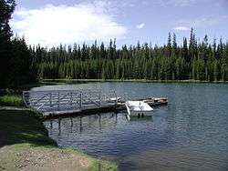 Dock at Jubilee Lake | |
| Location | Union County, Oregon, United States[1] |
| Coordinates | 45°49′53″N 117°57′39″W / 45.8315005°N 117.9607769°WCoordinates: 45°49′53″N 117°57′39″W / 45.8315005°N 117.9607769°W[1] |
| Type | Reservoir[1] |
| Primary inflows | Motett Creek and seasonal streams from melting snow[2] |
| Primary outflows | Motett Creek |
| Catchment area | 4.2 sq mi (11 km2)[3] |
| Managing agency | U.S. Forest Service[4] |
| Built | 1967–1968[2][3] |
| Surface area | 92.33 acres (37.36 ha)[2] |
| Average depth | 16 ft (4.9 m)[5] |
| Max. depth | 45 ft (14 m)[5] |
| Water volume | 62,639,280 cu ft (1,773,747 m3)[5] |
| Residence time | 2 months[5] |
| Shore length1 | 2.6 mi (4.2 km)[2] |
| Surface elevation | 4,761 ft (1,451 m)[6] |
| 1 Shore length is not a well-defined measure. | |
Jubilee Lake is a 92.33-acre (37.36 ha) man-made lake in the Umatilla National Forest in the northern corner of Union County in the U.S. state of Oregon.[1][2] It is located 19 miles (31 km) north of Elgin and about 11 miles (18 km) south of the Washington border, at an elevation of 4,761 feet (1,451 m).[6][7] Its basin spans Union, Umatilla, and Wallowa counties.[8] The lake was made for recreation in 1968 when an earthen dam, 350 feet (110 m) long and 50 feet (15 m) high, was constructed on Motett Creek. A U.S. Forest Service campground at the lake has 53 sites and is the most heavily used campground in the Umatilla National Forest. Fishing and swimming are the most popular activities at the lake. A 2.8-mile (4.5 km) trail around the shore was designated a National Recreation Trail in 1981.[2][3][4][9]
Jubilee Lake is considered mesotrophic, with an intermediate level of biological activity,[2] and its drainage basin receives about 50 inches (1,300 mm) of precipitation annually.[3] Rainbow trout are stocked in the lake for anglers, and youth fishing event is held at the lake each year.[10][11]
See also
References
- 1 2 3 4 "Jubilee Lake". Geographic Names Information System. United States Geological Survey. November 28, 1980. Retrieved April 8, 2013.
- 1 2 3 4 5 6 7 "Jubilee Lake (Union)". Atlas of Oregon Lakes. Portland State University. 1985–2014. Retrieved July 3, 2014.
- 1 2 3 4 "Basin Statistics" (PDF). Atlas of Oregon Lakes. Portland State University. Retrieved July 3, 2014.
- 1 2 "Jubilee Lake Campground". U.S. Forest Service. Retrieved April 8, 2013.
- 1 2 3 4 Johnson, Daniel M.; Petersen, Richard R.; Lycan, D. Richard; Sweet, James W.; Neuhaus, Mark E., and Schaedel, Andrew L. (1985). Atlas of Oregon Lakes (PDF). Corvallis, Oregon: Oregon State University Press. p. 219. ISBN 0-87071-343-4. OCLC 59940529. Retrieved July 3, 2014.
- 1 2 Surface elevation derived from Google Earth search using GNIS coordinates.
- ↑ The National Map (Map). National Hydrography Dataset. U.S. Geological Survey. Retrieved April 12, 2013.
- ↑ "Jubilee Lake: Union County" (PDF). Atlas of Oregon Lakes. Portland State University. Retrieved July 3, 2014.
- ↑ "Jubilee Lake". American Trails. Retrieved April 12, 2013.
- ↑ "Jubilee Lake". Oregon Department of Fish and Wildlife. Archived from the original on July 7, 2013.
- ↑ Schuhmann, Craig (2012). Oregon Fishing (2nd ed.). Berkeley, California: Avalon Travel. p. 271. ISBN 9781612381688. OCLC 757477054.
External links
- Photos of the lake by Evan Stroum
- Featured lakes on the Umatilla National Forest: U.S. Forest Service