Junction Canal
| Junction Canal | |
|---|---|
|
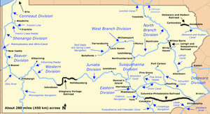
Map of historic Pennsylvania canals and connecting railroads | |
| Specifications | |
| Locks | 11 |
| Status | Abandoned except for historic interest |
| History | |
| Original owner | Junction Canal Company |
| Construction began | 1853 |
| Date of first use | 1854 |
| Date completed | 1858 |
| Date closed | 1871 |
| Geography | |
| Start point | Elmira, New York |
| End point | Athens, Pennsylvania |
| Connects to | Chemung Canal, Pennsylvania Canal (North Branch Division) |
The Junction Canal was a canal in the states of New York and Pennsylvania in the United States. The canal was also called the Arnot Canal, after the name of its principal stockholder, John Arnot of Elmira, New York. The canal was built and operated by a private stock company. The canal was partly open in 1854, but the entire length was not finished until 1858. The completed canal was 18 miles (29 km) long and had 11 locks. Then intent was to lengthen the reach of the Chemung Canal deeper into Pennsylvania in order to connect to the canal systems there. Competition with railroads led to diminished use of the canal. In 1865 the canal was severely damaged by a flood. In 1866, the stock company was authorized to change its name to the "Junction Canal and Railroad Company," and work commenced in constructing a railroad on its right of way. The canal was last used in 1871, and was then abandoned.[1]
Points of interest
| Feature | Coordinates | Description |
|---|---|---|
| Elmira, New York | 42°05′23″N 76°48′28″W / 42.08972°N 76.80778°WCoordinates: 42°05′23″N 76°48′28″W / 42.08972°N 76.80778°W[2] | City at the northern terminus |
| Athens, Pennsylvania | 41°57′26″N 76°31′05″W / 41.95722°N 76.51806°W[3] | Borough near the southern terminus |
See also
References
- ↑ Whitford, Noble E. (1906). Supplement to the Annual Report of the State Engineer and Surveyor of the State of New York: History of the Canal System of the State of New York Together with Brief Histories of the Canals of the United States and Canada, Volume I, Chapter XXI: The Junction Canal. Albany: Brandow Printing Company. Retrieved March 18, 2009.
- ↑ "Elmira". Geographic Names Information System. United States Geological Survey. August 2, 1979. Retrieved March 21, 2009.
- ↑ "Athens". Geographic Names Information System. United States Geological Survey. August 30, 1990. Retrieved March 19, 2009.