K-64 (Kansas highway)
| ||||
|---|---|---|---|---|
 | ||||
| Route information | ||||
| Maintained by KDOT | ||||
| Length: | 3.574 mi[1] (5.752 km) | |||
| Existed: | c. 1932 [2] – present | |||
| Major junctions | ||||
| West end: |
| |||
| North end: |
| |||
| Location | ||||
| Counties: | Pratt | |||
| Highway system | ||||
| ||||

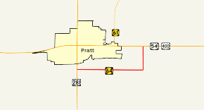
K-64 was a 3.574-mile-long (5.752 km) state highway in Pratt County, Kansas. The highway was a partial bypass of Pratt that ran from U.S. Route 281 (US-281) just south of the city limits to US-54/US-400 east of them. The route was maintained by the Kansas Department of Transportation until July 2016 when the road was turned over to Pratt County. K-64 was not part of the National Highway System. K-64 was designated at around 1932 and paved in 1937.
K-64 was decommissioned when the Kansas Department of Transportation expanded several miles of U.S. 54 east of Pratt to four lanes. In exchange for the expansion, Pratt County agreed to take control of K-64.
Route description
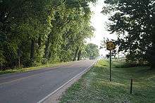
K-64 began at an intersection with US-281 just south of Pratt. The highway went east on a two-lane road through a hilly, slightly wooded area. The road passed south of an unnamed lake, then turned to the north. The route then crossed the south fork of the Ninnescah River and the Kansas and Oklahoma Railroad before reaching its northern terminus at a T intersection with US-54 and US-400.[3][4]
K-64 was maintained by the Kansas Department of Transportation (KDOT). In 2012, the traffic on the route, calculated in annual average daily traffic, was 750 vehicles on the north–south section and 1260 vehicles on the east–west section.[5] K-64 is not a part of the National Highway System,[6] a system of highways considered important to the nation's defense, economy, and mobility.[7]
History
K-64 was designated at around 1932.[2] The route was paved with an oil surface in 1937,[8][9] and it has not changed since then.[9][10]
Major intersections
The entire route is in Pratt County.
| Location | mi[1] | km | Destinations | Notes | |
|---|---|---|---|---|---|
| | 0.000 | 0.000 | Western terminus | ||
| | 3.574 | 5.752 | Northern terminus | ||
| 1.000 mi = 1.609 km; 1.000 km = 0.621 mi | |||||
References
- 1 2 "2012 Condition Survey Report for Pratt County, Kansas". Kansas Department of Transportation. Retrieved February 15, 2013.
- 1 2 Kansas State Highway System (PDF) (Map) (1932 ed.). State Highway Commission of Kansas. Retrieved February 15, 2013.
- ↑ Kansas Railroad Map 2011 (PDF) (Map). Kansas Department of Transportation. Retrieved February 15, 2013.
- ↑ Google (February 15, 2013). "K-64 (Kansas highway)" (Map). Google Maps. Google. Retrieved February 15, 2013.
- ↑ 2012 Traffic Flow Map of the Kansas State Highway System (PDF) (Map). Kansas Department of Transportation. Retrieved February 15, 2013.
- ↑ National Highway System: Kansas (PDF) (Map). Federal Highway Administration. October 1, 2012. Retrieved February 15, 2013.
- ↑ Natzke, Stefan; Neathery, Mike; Adderly, Kevin (September 26, 2012). "What is the National Highway System?". National Highway System. Federal Highway Administration. Retrieved January 15, 2013.
- ↑ Kansas State Highway System (PDF) (Map) (1936 ed.). State Highway Commission of Kansas. Retrieved February 15, 2013.
- 1 2 Kansas State Highway System (PDF) (Map) (1937 ed.). State Highway Commission of Kansas. Retrieved February 15, 2013.
- ↑ Official Kansas State Transportation Map (PDF) (Map) (2013-14 ed.). Kansas Department of Transportation. Retrieved February 15, 2013.