Kalamu
| Kalamu | |
|---|---|
| Commune | |
 Kalamu on a map of Kinshasa communes | |
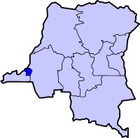
 Kinshasa city-province on a map of the DRC | |
| Coordinates: 04°20′51″S 15°19′12″E / 4.34750°S 15.32000°ECoordinates: 04°20′51″S 15°19′12″E / 4.34750°S 15.32000°E[1] | |
| Country | Democratic Republic of the Congo |
| Province | Kinshasa |
| District | Funa |
| Area | |
| • Total | 6.64 km2 (2.56 sq mi) |
| Population (2004 est.) | |
| • Total | 315,342 |
| • Density | 47,000/km2 (120,000/sq mi) |
Kalamu is a municipality (commune) in the Funa district of Kinshasa, the capital city of the Democratic Republic of the Congo.[2]
It forms the part of the city to the south of major buildings such as the Palais du Peuple ("Palace of the People"), the Stade des Martyrs ("Martyrs' Stadium") and Kinshasa's N'djili Airport.
The town contains the popular Matongé neighborhood, the Victoire roundabout and the Stade Tata Raphaël ("Father Raphael Stadium").
Demographics
| Year | 1967 | 1970 | 1984 | 2003 | 2004 |
|---|---|---|---|---|---|
| Population | 78,310 | 100,441 | 160,719 | 304,961 | 315,342 |
References
- ↑ "Kalamu, Kinshasa, Democratic Republic of the Congo". Google Maps. Retrieved 20 August 2011.
- ↑ "Géographie de Kinshasa (Geography of Kinshasa)" (in French). Ville de Kinshasa (City of Kinshasa). Retrieved 20 August 2011.
See also
| Wikimedia Commons has media related to Kalamu. |
This article is issued from Wikipedia - version of the 11/9/2016. The text is available under the Creative Commons Attribution/Share Alike but additional terms may apply for the media files.