Kamener Kreuz
| Kamener Kreuz | |
|---|---|
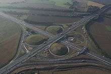 Aerial view of the Kamener Kreuz | |
| Location | |
| Kamen, near Dortmund, Germany | |
| Coordinates: | 51°36′03″N 7°41′14″E / 51.60083°N 7.68722°ECoordinates: 51°36′03″N 7°41′14″E / 51.60083°N 7.68722°E |
| Roads at junction: | |
| Construction | |
| Opened: | 1937 |
| Map | |
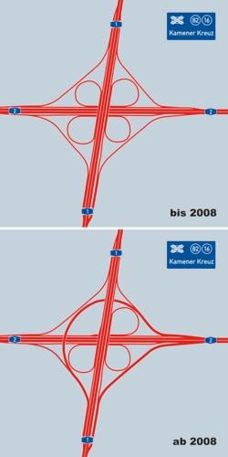 | |
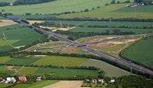
The Kamener Kreuz was formerly a full cloverleaf interchange near Dortmund in North Rhine-Westphalia Germany where the Autobahnen A1 and A2 meet. It lies between the towns of Kamen and Bergkamen in the west and the city of Hamm and the municipality Bönen in the east. The Kamener Kreuz, opened in 1937, was the second interchange between two Reichsautobahnen, the first one being the Schkeuditzer Kreuz. It is used by 160,000 vehicles per day.
Between 2006 and 2009, the Kamener Kreuz was renovated and upgraded to three lanes in each direction. This required to replace the old A1 bridge by a new one. Additionally, an overfly ramp from A2-East (Hannover) to A1-South (Cologne) was built, so the interchange had no longer the shape of a classic cloverleaf.
The portion of the A1 between the Kamener Kreuz and Dreieck Erftal is traditionally one of the most congested sections of Autobahn in Germany.[1]
References
- ↑ Staff writer (16 October 2009). "Koalition will Standstreifen bei Stau freigeben" [Coalition wants the release of the emergency lane during congestion]. Die Welt. Retrieved 26 December 2015.
- ↑ "'Gelber Engel' im Kamener Kreuz 'gelandet'". Retrieved 2016-02-18.
External links
![]() Media related to Kamener Kreuz at Wikimedia Commons
Media related to Kamener Kreuz at Wikimedia Commons