Kapan
| Kapan Կապան | ||
|---|---|---|
| community | ||
|
From top left:
| ||
| ||
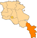
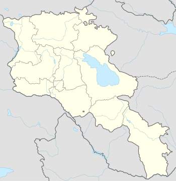 Kapan Location of Kapan in Armenia | ||
| Coordinates: 39°12′04″N 46°24′54″E / 39.20111°N 46.41500°ECoordinates: 39°12′04″N 46°24′54″E / 39.20111°N 46.41500°E | ||
| Country |
| |
| Marz (Province) | Syunik | |
| Founded | 10th century | |
| City status | 1938 | |
| Government | ||
| • Mayor | Arthur Atayan | |
| Area | ||
| • Total | 36 km2 (14 sq mi) | |
| Elevation | 910 m (2,990 ft) | |
| Population (2011 census)[1] | ||
| • Total | 43,190 | |
| • Density | 1,200/km2 (3,100/sq mi) | |
| Time zone | AMT (UTC+4) | |
| Postal code | 3301-3308 | |
| Area code(s) | (+374) 285 | |
| Website | Official website | |

Kapan (Armenian: Կապան), is a town in southeast Armenia and the capital of the Syunik Province. It is located on the northern slopes of Mount Khustup, in the valley of the Voghji River. According to the 2011 census, the population of Kapan is 43,190,[2] slightly declined from 45,711 in the 2001 census.[3] Kapan is the most populous town in the Syunik Province and the entire region of southern Armenia.
The town was known as Ghapan (Armenian: Ղափան) during the Soviet period.
Etymology
The word Kapan originates from the Armenian verb kapel/gabel (կապել), meaning "to lock", and points to an old Armenian geographic term for valleys surrounded by interlocked mountain chains.[4]
History

The area of modern-day Kapan was first mentioned in the 5th century as a small settlement. Historically, the town was part of the Baghk canton of Syunik, the 9th province of the historic Kingdom of Armenia (Armenia Major). By the end of the 10th century, the ruler of Syunik; prince Smbat II, moved to the town of Kapan and founded the Kingdom of Syunik, proclaiming himself a king under the protectorate of the Bagratid Kingdom of Armenia.
In 1103, Kapan was entirely ruined by the Seljuk invaders. Between the 12th and 15th centuries, Syunik along with the rest of the historic territories of Armenia suffered from the Seljuk, Mongol, Ag Qoyunlu and Kara Koyunlu invasions, respectively.
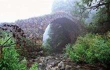
At the beginning of the 16th century, Kapan became part of the Erivan Beglarbegi within the Safavid Persia. By the beginning of the 18th century, Kapan was associated with the Armenian military leader David Bek, who led the liberation campaign of the Armenians of Syunik against Safavid Persia and the invading Ottoman Turks. David Bek started his battles in 1722 with the help of thousands of local Armenian patriots who liberated Syunik.[5] The centre of David Bek's struggle was the Baghaberd Fortress northwest of Kapan and Halidzor Fortress southwest of Kapan where he died in 1728.
Kapan became a significant urban settlement during the Qajar Persian rule in the 18th century. In 1828, Kapan was officially became part of the Russian Empire as a result of the Russo-Persian War of 1826–28 and the signing of the Treaty of Turkmenchay. With the merger of several villages, Kapan was formed as an urban community during the 19th century.
In 1938, Kapan was given the status of a town by the Soviet government of Armenia.[6] Present-day Kapan is built around 10 km (6 mi) southeast of the old town.
Kapan used to have a small Jewish community.
Geography and climate

Kapan is the largest town in the Syunik province as well as the entire region of southern Armenia. It is located in the eastern part of Syunik, within the narrow valley of Voghji River on a length of 13 km (8 mi) form the east to the west, at the southeastern slopes of the Zangezur Mountain Range, between the Bargushat and Meghri ridges.
The town is about 80 km (50 mi) north of the Iranian border.
With a height of 3201 meters, Mount Khustup is the highest peak of the region. The elevation of Kapan ranges between 750–1050 metres above sea level, with an average height of 910 metres.
The tributaries of Voghji River, Vachagan and Kavart flow through the town as well.
Kapan is characterized with hot summers and cold winters. Temperature could reach up to 38 °C (100 °F) during summer, and could fall down to −15 °C (5 °F) during winter.
The Shikahogh State Preserve, founded in 1958, is located around 14 km (9 mi) south of Kapan, near the Shikahogh village. The preserve is home to about 1,100 species of plants, 70 of which have been registered in the Red Book of Armenia. The fauna of Shikahogh has not been fully explored, but studies have already revealed rare species of animals such as leopard, wild goat, bear, viper, and hedgehog.[7][8]
| Climate data for Kapan | |||||||||||||
|---|---|---|---|---|---|---|---|---|---|---|---|---|---|
| Month | Jan | Feb | Mar | Apr | May | Jun | Jul | Aug | Sep | Oct | Nov | Dec | Year |
| Average high °C (°F) | 7.1 (44.8) |
8.4 (47.1) |
11.7 (53.1) |
17.1 (62.8) |
21.8 (71.2) |
25.8 (78.4) |
29.3 (84.7) |
29.3 (84.7) |
24.4 (75.9) |
19.8 (67.6) |
13.1 (55.6) |
9.0 (48.2) |
18.1 (64.6) |
| Average low °C (°F) | −13.0 (8.6) |
−12.0 (10.4) |
−8.0 (17.6) |
−1.0 (30.2) |
4.0 (39.2) |
8.0 (46.4) |
11.0 (51.8) |
11.0 (51.8) |
7.0 (44.6) |
1.0 (33.8) |
−6.0 (21.2) |
−10.0 (14) |
−0.7 (30.7) |
| Average rainfall mm (inches) | 28 (1.1) |
32 (1.26) |
60 (2.36) |
80 (3.15) |
96 (3.78) |
68 (2.68) |
31 (1.22) |
30 (1.18) |
43 (1.69) |
55 (2.17) |
40 (1.57) |
27 (1.06) |
590 (23.23) |
| Average rainy days | 7 | 7 | 11 | 12 | 15 | 10 | 4 | 4 | 7 | 8 | 7 | 6 | 96 |
| Source: World Meteorological Organization[9] | |||||||||||||
Demographics
Kapan is almost entirely populated by ethnic Armenians who belong to the Armenian Apostolic Church. The town's main church is the Saint Mesrop Mashtots Church opened in December 2001. It belongs to the Diocese of Syunik of the Armenian Apostolic Church, based in the nearby town of Goris.[10]
| Historical population | |||||||||||||||||||||||||||||||||||
|---|---|---|---|---|---|---|---|---|---|---|---|---|---|---|---|---|---|---|---|---|---|---|---|---|---|---|---|---|---|---|---|---|---|---|---|
|
|
| |||||||||||||||||||||||||||||||||
Culture


The Kapan Museum of Geology and the History Museum named after Shmavon Movsisyan are among the prominent cultural structures of the town.
The area around Kapan has a plenty of historical structures including:
- Baghaberd Fortress of the 4th century, also known as the castle of Davit Bek.
- Tatev Monastery of the 9th century, founded in the place of an ancient tabernacle well known in ancient times.
- Vahanavank Monastery of the 11th century.
- Halidzor Fortress of the 17th century.
The town has many attractive structures including:
- Kapan Archaeological and Ethnographic Museum.
- Monument dedicated to David Bek.
- Garegin Nzhdeh's memorial and park.
- Vazgen Sargsyan central park.
- "Karapeti Gyol" artificial lake.
- Garegin Nzhdeh Square.
Wings of Tatev cableway which connects Halidzor village with the Tatev monastery is located 24 km (15 mi) north of Kapan. It is the longest reversible aerial tramway built in one section only.[11]
Media
Kapan has 2 local TV companies: Khustup TV and Sosi TV. Khustup TV was founded in 2004 and covers the entire region of Syunik.[12] Sosi TV founded in 2012, covers the middle and southern parts of Syunik.
Transportation
The M-2 Motorway that connects the capital Yerevan with southern Armenia, Iranian border and the Nagorno-Karabakh Republic passes through Kapan.
In late 2008, the road between Kapan and Meghri on the Iranian border was redeveloped. However The railway line Kapan-Kovsakan-Mijnavan is currently inactive.
Prior to the Nagorno-Karabakh War, the nearby airfield accommodated the aircraft YAK-40 and AN-14 cargo.
The nearest airport to the town is the defunct Goris Airport located 62 km (39 mi) north of Kapan, near the town of Goris.[13]
Economy
With a population of around 45,500, Kapan is struggling to cope with the realities of post-Karabakh war and post-Soviet society. However, there are signs of growth and development. Kapan is primarily a mining centre, hence its Persian name of the Qajar time معدن (Ma'dan, meaning "mine"). Kapan's industry is dependent on the newly privatized polymetallic deposit, though additional operations have developed including mining support services, commercial scale animal husbandry, and an expanding retail sector. The furniture and textile industries have grown in recent years.
Kapan has been a major centre for the production of many non-ferrous metals. Commercial development of the local deposits began in 1890. Armenian entrepreneurs and French mining engineers obtained concessions to the copper mines and a copper-ore processing plant was built in the city.
Nowadays, Kapan is home to a number of industrial firms operating in the industrial district of the town. The largest firms are the "Kapan CH.SH.SH." for building materials founded in 1947, the Kapan machine tools plant founded in 1972, the "Sonatex" knitting factory founded in 1985, and the "Marila LLC" for meat and dairy products founded in 2010.
Education
Kapan is the education centre of southern Armenia. It has 13 public education schools, 3 music schools and 3 sport academies.
The Kapan campus of the National Polytechnic University of Armenia[14][15] is home to two faculties:
- Faculty of Technologies and sectoral economics,
- Faculty of Natural sciences and communication systems.
Sport
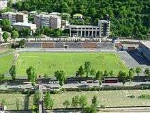
Association football is the most popular sport in the town. Gandzasar Kapan FC, founded in 2004, are representing the town in the Armenian Premier League. They play their home games at the Gandzasar Stadium. The club won the 3rd place of the Armenian Premier League on 3 occasions: in 2008, 2011 and 2012-13. Gandzasar have the highest average attendance at home games in the league.
In May 2013, Gandzasar Kapan opened their football training centre at the outskirts of Kapan. The new complex has many regular-sized football pitches including one with artificial turf. The academy became the first developed technical football centre in the Syunik Province.[16]
Basketball, artistic gymnastics, boxing and athletics are among the widely practiced sports in Kapan.
Notable natives

- Aram Manukian, Armenian politician and revolutionary
- Karen Sargsyan, principal choirmaster of the Armenian Opera Theater
- David Ambartsumyan, Soviet Armenian diver, European champion
- Armen Movsisyan, former minister of energy of Armenia
- Tatoul Markarian, ambassador of Armenia to the European Union
- Lusine Gevorkyan, lead singer of Russian nu metal bands Tracktor Bowling and Louna
International relations
Twin towns – Sister cities
References
- ↑ Syunik
- ↑ census 2011
- ↑ Report of the results of the 2001 Armenian Census, National Statistical Service of the Republic of Armenia
- ↑ Western Armenian Dictionary & Phrasebook: Armenian-English/English-Armenian (Hippocrene Dictionary and Phrasebook). 2006. p. 86
- ↑ Капан (in Russian). abp.am. Retrieved August 28, 2009.
- ↑ About Kapan
- ↑ Igor G. Khorozyan, Pavel I. Weinberg and Alexander G. Malkhasyan: Conservation Strategy for Armenian Mouflon (Ovis orientalis gmelini Blyth) and Bezoar Goat (Capra aegagrus Erxleben) in Armenia. in Status and Protection of globally threatened Species in the Caucasus. CEPF Biodiversity Investments in the Caucasus Hotspot 2004-2009. Edited by Nugzar Zazanashvili and David Mallon (2009).online PDF
- ↑ Armenia Tree Project - Environmental News and Analysis
- ↑ "World Weather Information Service – Kapan". World Meteorological Organization. Retrieved 24 September 2016.
- ↑ The church of Kapan is open
- ↑ World's longest cable car line opens to Armenia. PhysOrg.com. Retrieved on 2011-06-15.
- ↑ About Khustup TV
- ↑ Waiting rooms and cafes to be constructed at stations of Tatev aerial tramway
- ↑ Faculty of Natural sciences and communication systems, Kapan campus
- ↑ Faculty of Technologies and sectoral economics, Kapan campus
- ↑ Gandzasar football academy
- ↑ "Interactive City Directory". Sister Cities International. Retrieved 11 March 2014.
- Kiesling, Rediscovering Armenia, p. 100–102, available online at the US embassy to Armenia's website
- Report of the results of the 2001 Armenian Census, National Statistical Service of the Republic of Armenia
- World Gazetteer: Armenia – World-Gazetteer.com
External links
| Wikimedia Commons has media related to Kapan. |
| Wikivoyage has a travel guide for Kapan. |