Kattikkulam, Wayanad
| Kattikkulam | |
|---|---|
|
Kattikkulam Nair temple | |
| Coordinates: 11°50′49″N 76°03′47″E / 11.84683°N 76.06313°ECoordinates: 11°50′49″N 76°03′47″E / 11.84683°N 76.06313°E | |
| Country |
|
| State | Kerala |
| District | Wayanad |
| Time zone | IST (UTC+5:25) |
| PIN | 670646 |

Kattikkulam is a small town near Mananthavady in Wayanad district, Kerala, India.
Location
Kattikkulam is located on the Mysore road from Mananthavady. Being a border town, it has many checkposts and forest offices.
Important Organizations
- St Peters Malankara Catholic Church
- NSS Temple
- Kattikkulam Higher Secondary School
- Thirunelly Panchayath Office
- Holiday Hill
- Kattikkulam Checkpost
Pakshi Pathalam
Pakshi Pathalam is a trekking site some seven kilometers from Thirunelli temple near Kattikkkulam. There is an ancient cave on the hillock with plenty of birds.
Bavali Bridge
Bavali bridge separates Kerala state from Karnataka state on the Mysore road from Kattikkuam. There two separate Bavali villages on either side of the bridge. Two government checkposts are also situataed here. The Bavali Sunni Dargah is a popular pilgrimage center and an annual festival called Uroos is conducted here.
Transportation
Kattikkulam can be accessed from Mananthavady or Kalpetta. The Periya ghat road connects Mananthavady to Kannur and Thalassery. The Thamarassery mountain road connects Calicut with Kalpetta. The Kuttiady mountain road connects Vatakara with Kalpetta and Mananthavady. The Palchuram mountain road connects Kannur and Iritty with Mananthavady. The road from Nilambur to Ooty is also connected to Wayanad through the village of Meppadi.
The nearest railway station is at Mysore and the nearest airports are Kozhikode International Airport-120 km, Bengaluru International Airport-290 km, and Kannur International Airport, 58 km.
Image Gallery
 Kattikkulam school
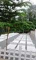 Kattikkulam Cemetry
 Kattikkulam Church
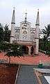 Kattikkulam Church
Location
 |
Thirunelly Forest | Kutta | Nalkeri Forest | |
| Boys Town | |
Mysore city | ||
| ||||
| | ||||
| Mananthavady | Panamaram | Pulpally |