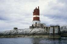
Kaura Lighthouse
 | |
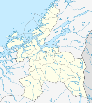 Sør-Trøndelag | |
| Location |
Kaura Island Sør-Trøndelag Norway |
|---|---|
| Coordinates | 64°13′48.9″N 10°07′59″E / 64.230250°N 10.13306°ECoordinates: 64°13′48.9″N 10°07′59″E / 64.230250°N 10.13306°E |
| Year first constructed | 1931 |
| Automated | 1959 |
| Foundation | stone basement |
| Construction | cast iron tower |
| Tower shape | massive cylindrical tower with balcony abd lantern incorporating keeper's quarter |
| Markings / pattern | red tower with one white band, white basement |
| Height | 22 metres (72 ft) |
| Focal height | 30 metres (98 ft) |
| Intensity | 4,050 candela |
| Range | 11.1 nmi (20.6 km; 12.8 mi) |
| Characteristic | Fl (2) WRG 10s. |
| Admiralty number | L1682 |
| NGA number | 8432 |
| ARLHS number | NOR-135 |
| Norway number | NF-4858[1] |
Kaura lighthouse (Norwegian: Kaura fyr) is a lighthouse located in the municipality of Roan in Sør-Trøndelag county, Norway. The 22-metre (72 ft) tall tower is located on the small island of Kaura in the mouth of the Brandsfjorden about 9 kilometres (5.6 mi) west of Bessaker and 8 kilometres (5.0 mi) northwest of the municipal center of Roan.[2]
The lighthouse was built in 1931 and automated in 1959. It can be seen for 11.1 nautical miles (20.6 km; 12.8 mi) and it has a flashing light in white, red, and green.[3]
See also
References
- ↑ Kaura Lighthouse The Lighthouse Directory. University of North Carolina at Chapel Hill. Retrieved March 6, 2016
- ↑ Store norske leksikon. "Kaura fyr" (in Norwegian). Retrieved 2011-01-03.
- ↑ Kystverket (2008). Norske Fyrliste 2008 (PDF) (in Norwegian). ISBN 978-82-450-0628-5.
External links
This article is issued from Wikipedia - version of the 10/22/2016. The text is available under the Creative Commons Attribution/Share Alike but additional terms may apply for the media files.