Keningau Airport
| Keningau Airport 根地咬机场 | |||||||||||
|---|---|---|---|---|---|---|---|---|---|---|---|
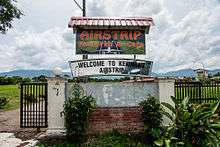 The main entrance to Keningau Airport | |||||||||||
| IATA: KGU – ICAO: WBKG | |||||||||||
| Summary | |||||||||||
| Airport type | Private and Public | ||||||||||
| Owner | Government of Malaysia | ||||||||||
| Location | Interior Division, Sabah, East Malaysia | ||||||||||
| Time zone | MST (UTC+08:00) | ||||||||||
| Elevation AMSL | 1,036 ft / 316 m | ||||||||||
| Coordinates | 05°21′19″N 116°09′54″E / 5.35528°N 116.16500°ECoordinates: 05°21′19″N 116°09′54″E / 5.35528°N 116.16500°E | ||||||||||
| Map | |||||||||||
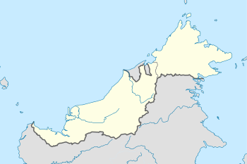 WBKG Location in Malaysia | |||||||||||
| Runways | |||||||||||
| |||||||||||
Keningau Airport (Malay : Lapangan Terbang Keningau) (IATA: KGU, ICAO: WBKG) is a privately owned and domestic airport serving the citytown of located at Keningau in the state of Sabah, Malaysia. It just 2.5 km from Keningau Town.
History

Many years ago, the Keningau Airport was used for aeroplanes with a small capacity like the BN-2 Islander and Fokker 50. The last flight to Keningau Airport for Malaysia Airlines was in the 1970s.
Airlines and Destinations
Malaysia Airlines used to fly from Subang Airport (now Kuala Lumpur International Airport) to Keningau Airport. When Malaysia Airlines stop their operation, they ended the Kuala Lumpur-Keningau route and turn it an abondened airport because hence there is no scheduled commercial airlines currently flying to the airport.
See also
References
- ↑ AIP Malaysia: Index to Aerodromes at Department of Civil Aviation Malaysia