Kharehpu
| Kharehpu خره پو | |
|---|---|
| village | |
|
village view | |
 Kharehpu | |
| Coordinates: 36°43′57″N 49°53′19″E / 36.73250°N 49.88861°ECoordinates: 36°43′57″N 49°53′19″E / 36.73250°N 49.88861°E | |
| Country |
|
| Province | Gilan |
| County | Rudbar |
| Bakhsh | Amarlu |
| Rural District | Kalisham |
| Elevation | 1,601 m (5,253 ft) |
| Population (2006) | |
| • Total | 343 |
| Time zone | IRST (UTC+3:30) |
| • Summer (DST) | IRDT (UTC+4:30) |
| Area code(s) | 0132629 |
| Website | http://www.khorramkoh.ir |
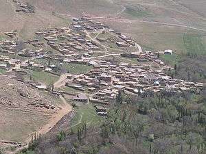
Kharehpu (Persian: خره پو, also Romanized as Kharehpū; also known as Kharapu and Khorramkoh)[1] is a village in Kalisham Rural District, Amarlu District, Rudbar County, Gilan Province, Iran. The village is located at 20 kilometers (12 mi) north-east of Jirandeh, at an altitude of 1,601 metres (5,253 ft) above sea level in the southern part of the province. At the 2006 census, its population was 343, in 107 families.[2]
References
- ↑ Kharehpu can be found at GEOnet Names Server, at this link, by opening the Advanced Search box, entering "-3070693" in the "Unique Feature Id" form, and clicking on "Search Database".
- ↑ "Census of the Islamic Republic of Iran, 1385 (2006)". Islamic Republic of Iran. Archived from the original (Excel) on 2011-11-11.
- سایت روستای خُرّمکوه
- "kharapu,khorramkoh in wiki farsi"
- E. Arabani Modified: book Gilan
- Specified culture
- Lexicon Dehkhoda
- Yasnt Louis Rabynv: Province Darlmrzgylan
- Book of Amarlu - M.M.Zand
- http://www.fallingrain.com/world/IR/8/Kharapu.html
See also
- 1990 Iran earthquake (Manjil-Rudbar Earthquake)
| Capital | |||||||||||||||||||||||||||||||||||||||||||||||||||||||||||
|---|---|---|---|---|---|---|---|---|---|---|---|---|---|---|---|---|---|---|---|---|---|---|---|---|---|---|---|---|---|---|---|---|---|---|---|---|---|---|---|---|---|---|---|---|---|---|---|---|---|---|---|---|---|---|---|---|---|---|---|
| Districts |
| ||||||||||||||||||||||||||||||||||||||||||||||||||||||||||
This article is issued from Wikipedia - version of the 8/22/2016. The text is available under the Creative Commons Attribution/Share Alike but additional terms may apply for the media files.