Khlong Saen Saep
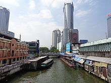
Khlong Saen Saep (Thai: คลองแสนแสบ, IPA: [kʰlɔ̄ːŋ.sɛ̌ːn.sɛ̀ːp]) is a canal (khlong) in central Thailand, connecting the Chao Phraya River to Prachin Buri and Chachoengsao. A portion of the canal is used for public transport by an express boat service in Bangkok. The canal is lined with concrete walkways on either side in many areas where people stroll. In other areas the heavily polluted water oozes into adjacent properties, especially after heavy rainstorms. The canal is connected to many other canals in a large network, though most of the other canals do not have a regular transport service.
History
The Saen Saep canal was built by the order of King Rama III during the conflict between Siam and Annam about Cambodia, to establish a water transport for soldiers and weapons to Cambodia. The construction started in 1837 and was finished three years after.[1] Klong Saen Saep was once filled with and abundance of lotus, King Mongkut in his 4th reign (1851-1868) built Sra Pathum Palace (Lotus Pond Palace) in Siam District, the names of the palace and present Pathum Wan district come from it.[2]
The Saen Saep starts from Mahanak canal or Khlong Mahanak (Thai: คลองมหานาค) around Mahakan Fortress (Thai: ป้อมมหากาฬ) in Bangkok. In Chachoengsao it terminates into the Bang Pa Kong River.
Public transportation
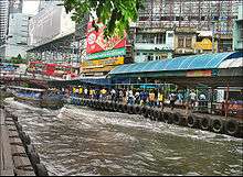
An express boat service operates on the Saen Saep between Pom Prap Sattru Phai and Bang Kapi districts, providing fast, inexpensive ferry transportation in traffic-congested central Bangkok. The service has a checkered reputation, due to the polluted water in the khlong and the haphazard nature in which the service is operated. The northern line terminates at Golden Mount, and the southern line terminates at NIDA. Boats go past Watthana and Huai Khwang districts, running parallel to Petchaburi Road.
References
- ↑ Shigeharu Tanabe: Historical Geography of the Canal System in the Chao Phraya Delta. In: Journal Of The Siam Society, Vol. 65 Part 2, The Siam Society, Bangkok 1977.
- ↑ 2bangkok.com:Bangkok's Crucible of Construction
External links
| Wikimedia Commons has media related to Khlong Saen Saeb. |
- detailed Route, Piers, and Map information for the Khlong Saen Saep Express Boat at KhlongSaenSaep.com
Coordinates: 13°44′57.88″N 100°32′25.04″E / 13.7494111°N 100.5402889°E