Khuruña
For other uses, see A Coruña (disambiguation).
| Khuruña | |
|---|---|
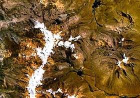 Barroso mountain range (on the left) as seen from space (NASA Landsat). Khuruña is visible in the upper part of the range. | |
| Highest point | |
| Elevation | 5,453 m (17,890 ft) [1] |
| Coordinates | 17°29′15″S 69°51′14″W / 17.48750°S 69.85389°WCoordinates: 17°29′15″S 69°51′14″W / 17.48750°S 69.85389°W [2] |
| Geography | |
 Khuruña Peru | |
| Location | Peru, Tacna Region |
| Parent range | Andes, Barroso |
Khuruña (Aymara for "to eat greedily",[3] Hispanicized spellings Coruna, Coruña) is a mountain in the Barroso mountain range in the Andes of Peru, about 5,453 metres (17,890 ft) high. It is situated in the Tacna Region, Tacna Province, Palca District, and in the Tarata Province, in the districts of Tarata and Tarucachi.[4] Khuruña lies southwest of Awki Taypi.
See also
References
- ↑ http://www..congreso.gob.pe, Ley que precisa el artículo 3º de la ley nº 27415, ley de demarcación territorial de la provincia de Tacna, Departamento de Tacna: "cumbres de los nevados ... Coruña (cota 5453 m.s.n.m.) ...
- ↑ mapcarta.com ""Nevado Coruna", retrieved on January 22, 2014
- ↑ Ludovico Bertonio, Aymara-Spanish Dictionary (transcription)
- ↑ escale.minedu.gob.pe - UGEL map of the Tacna Province (Tacna Region)
This article is issued from Wikipedia - version of the 6/12/2016. The text is available under the Creative Commons Attribution/Share Alike but additional terms may apply for the media files.