Khyargas Nuur
| Khyargas Lake | |
|---|---|
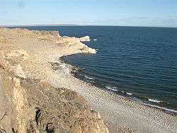 Khyargas Lake south-east shore | |
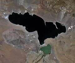 A satellite image of Lake Khyargas taken from Landsat-7. Smaller lake south of the Khyargas Lake is Airag Lake. | |
| Location | Khyargas district, Uvs Province |
| Coordinates | 49°08′N 93°25′E / 49.133°N 93.417°ECoordinates: 49°08′N 93°25′E / 49.133°N 93.417°E |
| Type | Endorheic |
| Primary inflows | Zavkhan River via Airag Nuur |
| Primary outflows | no |
| Basin countries | Mongolia |
| Max. length | 75 km |
| Max. width | 31 km |
| Surface area | 1,407 km² |
| Average depth | 47 m |
| Max. depth | 80 m |
| Water volume | 66.034 km³ |
| Residence time | 54.2 years |
| Surface elevation | 1,028.5 m |
| Islands | one unnamed |
| Settlements | no |

Khyargas
Khyargas (Mongolia)
Khyargas Lake (Mongolian: Хяргас нуур, Hĭargas núr) is a salt lake in Khyargas district, Uvs Province, Western Mongolia.
Some sources are using different Khyargas Lake statistics values:[1]
- Water level: 1,035.29 m
- Surface area: 1,481.1 km²
- Average depth: 50.7 m
- Volume: 75.2 km³.
| Surface input | Surface output | Groundwater inflow- outflow |
Retention time, years | ||
|---|---|---|---|---|---|
| Precipitation | Inflow | Evaporation | Outflow | ||
| 55.9 | 652.4 | 937.1 | 0 | +228.8 | 54.2 |
The Khyargas Lake National Park is based on the lake. This protected area was established in 2000 and covers about 3,328 km². It also includes a freshwater Airag Lake.[2][3]
References
- 1 2 "Surface Water of Mongolia", Gombo Davaa, Dambaravjaa Oyunbaatar, Michiaki Sugita
- ↑ "Mongolia", by Jane Blunden, from Bradt Travel Guides series, 2nd edition, 2008, ISBN 1-84162-178-1, p. 372
- ↑ "Mongolia", by Michael Kohn, 2008, ISBN 1-74104-578-9, p. 242
This article is issued from Wikipedia - version of the 10/12/2016. The text is available under the Creative Commons Attribution/Share Alike but additional terms may apply for the media files.