Kiantajärvi
| Kiantajärvi | |
|---|---|
 | |
| Location | Suomussalmi, Kainuu |
| Coordinates | 65°01′N 29°06′E / 65.017°N 29.100°ECoordinates: 65°01′N 29°06′E / 65.017°N 29.100°E |
| Primary inflows | river Hossanjoki, river Pesiönjoki from the lake Pesiöjärvi |
| Primary outflows | Emäjoki river, Aittokoski power station |
| Catchment area | Oulujoki |
| Basin countries | Finland |
| Max. length | 50 km (31 mi) |
| Surface area | 187.933 km2 (72.561 sq mi) |
| Average depth | 7.37 m (24.2 ft) |
| Max. depth | 43 m (141 ft) |
| Water volume | 1.385 km3 (1,123,000 acre·ft) |
| Shore length1 | 527.719 km (327.909 mi) |
| Surface elevation | 199.3 m (654 ft) |
| Frozen | November–May |
| Islands | 144 islands, biggest Salonsaari (2.71 km2) |
| Settlements | Suomussalmi |
| References | [1] |
| 1 Shore length is not a well-defined measure. | |
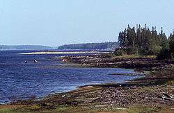
Kiantajärvi is a rather large lake in the Oulujoki main catchment area. It is located in Suomussalmi municipality, in the region Kainuu, Finland. It is the 24th biggest lake in Finland.[1] The lake is narrow and 50 km long in north–south direction. It player a significant role in the Battle of Suomussalmi during the Winter War in December 1939. Kiantajärvi is also known of the author Ilmari Kianto, who had his home named Turjanlinna on the shore of Niskaselkä open area. The author´s grave is situated in Niettussaari island near his home.
References
- 1 2 Kiantajärvi in Järviwiki Web Service. Finnish Environment Institute. Retrieved 2014-03-15. (English)
This article is issued from Wikipedia - version of the 9/4/2015. The text is available under the Creative Commons Attribution/Share Alike but additional terms may apply for the media files.