Kiischpelt
| Kiischpelt Kiischpelt | ||
|---|---|---|
| Commune | ||
|
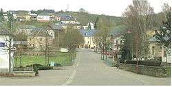
Wilwerwiltz | ||
| ||
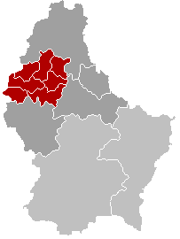
 Map of Luxembourg with Kiischpelt highlighted in orange, and the canton in dark red | ||
| Coordinates: 49°59′31″N 6°00′22″E / 49.9919°N 6.0061°ECoordinates: 49°59′31″N 6°00′22″E / 49.9919°N 6.0061°E | ||
| Country |
| |
| Canton | Wiltz | |
| Government | ||
| • Mayor | Armand Mayer | |
| Area | ||
| • Total | 33.58 km2 (12.97 sq mi) | |
| Area rank | 18 of 105 | |
| Highest elevation | 498 m (1,634 ft) | |
| • Rank | 19th of 105 | |
| Lowest elevation | 241 m (791 ft) | |
| • Rank | 49th of 105 | |
| Population (2014) | ||
| • Total | 1,091 | |
| • Rank | 97th of 105 | |
| • Density | 32/km2 (84/sq mi) | |
| • Density rank | 104th of 105 | |
| Time zone | CET (UTC+1) | |
| • Summer (DST) | CEST (UTC+2) | |
| LAU 2 | LU00005006 | |
| Website | kiischpelt.lu | |
.png)
Kiischpelt is a commune in northern Luxembourg, in the canton of Wiltz. The commune's administrative centre is Wilwerwiltz.
Towns within the commune are: Alscheid, Enscherange, Kautenbach, Lellingen, Merkholz, Pintsch, and Wilwerwiltz.
Kiischpelt was formed on 1 January 2006 from the former communes of Kautenbach and Wilwerwiltz, both in Wiltz canton. The law creating Kiischpelt was passed on 14 July 2005.[1]
Footnotes
- ↑ "Mémorial A, 2005, No. 116" (PDF) (in French). Service central de législation. Retrieved 2006-08-15.
External links
-
 Media related to Kiischpelt at Wikimedia Commons
 |
Clervaux | | ||
| Wiltz | |
Parc Hosingen | ||
| ||||
| | ||||
| Goesdorf | Bourscheid |
This article is issued from Wikipedia - version of the 12/1/2016. The text is available under the Creative Commons Attribution/Share Alike but additional terms may apply for the media files.