Kilbourne Hole
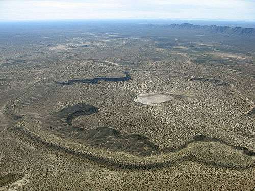
Kilbourne Hole is a maar volcanic crater, located 30 miles (48 km) west of the Franklin Mountains of El Paso, Texas, in the Potrillo volcanic field of Doña Ana County, New Mexico. Another maar, Hunt's Hole, lies just two miles south of Kilbourne Hole. These holes are rare examples of volcanic action without a mountainous rim.
The theory of maar formation is that rising magma super-heats water-saturated earth, far enough below the surface that a high pressure can be contained. At some point, the pressure is too much, and a steam explosion occurs, throwing the earth out in a catastrophic event.[1] Country rocks are fragmented and expelled in the atmosphere (together with fragments of the magma), eventually creating a deep crater, the bottom of which sits below the pre-eruptive ground surface.
Estimates of the age of the crater vary from about 24,000 to about 80,000 years.[2][3][4]
The volcanic features around El Paso and vicinity are part of the Potrillo volcanic field, in the Rio Grande rift, which extends northward into Colorado.
Description of the crater
- Latitude/Longitude: 31°58′19″N 106°57′53″W / 31.97194°N 106.96472°WCoordinates: 31°58′19″N 106°57′53″W / 31.97194°N 106.96472°W
- Elevation: 4,239 feet (1,292 m)
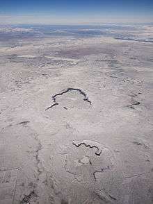
- Crater diameter: 1.5x2.1 miles (2.4x3.4 km)
- Depth: 443 feet (135 m)
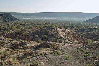
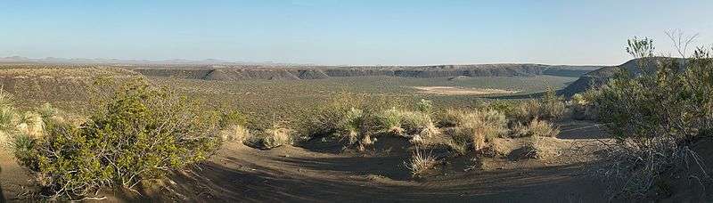
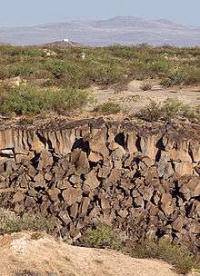
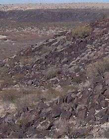
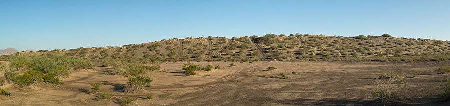
The hole is over a mile wide, and over 300 feet (91 m) deep, with crumbling basalt cliffs all around except at the southwest corner. The basalt cliffs resemble the cliffs of the Devils Postpile National Monument near Yosemite National Park, with the characteristic reddish purple hexagonal columns, except that they are not as tall. The cliffs are about 40 feet (12 m) high. Lava chunks exist in abundance. The basalt column fragments are each larger than a person.
Hunt's Hole is a little smaller, with basalt cliffs only at the northeast and southeast sides of the crater. Layers of ashfall and crumbling sediment also rise about 40 feet (12 m) high, on the south rim of the crater. This ashfall section on the south rim will not support a person's weight; it is safer to stay on the basalt cliffs and the sand dunes. Sand dunes have collected on the east sides of the both craters, rising about 100 feet (30 m) above the desert floor.
A dry lakebed lies on the floor of each crater.
Green peridot crystals occur in the lava.
Apollo astronauts trained in these craters in 1969.[5][6]
Hunt's Hole
Hunt's Hole is a similar but somewhat smaller maar, a few miles south of Kilbourne Hole; both are part of the Potrillo volcanic field.
Access

Kilbourne Hole is in BLM land and is available as an unimproved recreational area.[7] It is accessed via Doña Ana County Road A-011, driving 8 miles west from the railroad. The hole is "on the right, past the big tan dirt bank."[7] Much of the land inside the hole is private property. Hunt's Hole is about 2 miles south on A-013.
The area has a high amount of alien and contraband smuggling due to its closeness to the U.S. border with Mexico. It is not uncommon to see the U.S. Border Patrol patrolling the area.
References
- ↑ "Fossils/Kilbourne Hole". Desert Diary. UTEP Geology Dept. Retrieved 4 Aug 2012.
- ↑ Cordell, L. (1975). "Combined Geophysical Studies at Kilbourne Hole Maar". New Mexico Geological Society Guidebook: 26th Field Conference. University of New Mexico Press: 273–281.
- 1 2 Wood, Charles A.; Kienle, Jürgen (eds.) (1990). Volcanoes of North America: United States and Canada. Cambridge University Press. pp. 310–311. ISBN 0-521-36469-8.
- ↑ Leland H. Gile (1987). "A Pedogenic Chronology for Kilbourne Hole, Southern New Mexico: II. Time of the Explosions and Soil Events Before the Explosions". Soil Science Society of America Journal. 51 (3): 752–760. doi:10.2136/sssaj1987.03615995005100030033x.
- ↑ http://www.desertusa.com/mag06/apr/volcanoes.html Kilbourne Hole: Apollo Training Site
- ↑ http://history.nasa.gov/alsj/ap-geotrips.pdf Geology Field Exercises for Apollo Missions. p.8
- 1 2 "Kilbourne Hole Volcanic Crater". Retrieved 30 July 2012.