Kilburn, North Yorkshire
| Kilburn | |
 Cottages in Kilburn |
|
 Kilburn |
|
| Population | 227 (2011)[1] |
|---|---|
| OS grid reference | SE512797 |
| – London | 190 mi (310 km) SSE |
| District | Hambleton |
| Shire county | North Yorkshire |
| Region | Yorkshire and the Humber |
| Country | England |
| Sovereign state | United Kingdom |
| Post town | YORK |
| Postcode district | YO61 |
| Dialling code | 01347 |
| Police | North Yorkshire |
| Fire | North Yorkshire |
| Ambulance | Yorkshire |
| EU Parliament | Yorkshire and the Humber |
| UK Parliament | Thirsk and Malton |
Coordinates: 54°12′36″N 1°12′50″W / 54.210°N 1.214°W
Kilburn is a village and civil parish in North Yorkshire, England. It lies on the edge of the North York Moors National Park, and 6.2 miles (10.0 km) north of Easingwold.
History
The village is mentioned in the Domesday Book as "Chileburne" in the Yalestre hundred. At the time of the Norman invasion the lord of the manor was Arnketil, but was subsequently granted to Hugh, son of Baldric.[2] During the reign of Henry I the manor was passed to Rouen Cathedral in Normandy and subsequently to Roger de Mowbray, before ending with the Archbishop of York after the dissolution of the monasteries in the 16th century.[3]
Kilburn was historically a township and parish in the wapentake of Birdforth in the North Riding of Yorkshire. After 1837 it was part of the Thirsk and Helmsley Poor Law Unions. The parish, which covered 5,900 acres (24 km2) acres, comprised Kilburn, Oldstead, Thorpe-le-Willows, and Wass, of which Kilburn had the largest population.[4] The etymology of the name comes form two Old English words, ciele & burna, meaning "cool stream".[5]
Robert de Alneto, a monk from Whitby Abbey lived in a hermitage at Hood Grange, 2 miles (3 km) from the village. In 1138 Robert de Mowbray converted it into a Cistercian abbey, which later moved to Old Byland and subsequently moved again to Byland.[4]
Governance
The village lies within the Thirsk and Malton UK Parliament constituency. It also lies within the Stillington, North Yorkshire electoral division of North Yorkshire County Council and the White Horse ward of Hambleton District Council.[6] The local Parish Council has five members.[7]
Geography
The village consists of High Kilburn the former situated on a hillside and Low Kilburn in the valley on the banks of a stream. It lies about 7 miles (11 km) east from Thirsk. The nearest settlements are Wass 2.6 miles (4.2 km) to the east; Coxwold 2 miles (3 km) to the south-east; Carlton Husthwaite 1.9 miles (3 km) to the south-west and Thirkleby 2.3 miles (3.7 km) to the west.[6] There was a sandstone-quarry at Hood Hill.[4]
The 1881 UK Census recorded the population as 387.[3] The 2001 UK Census recorded the population as 180, of which 162 were over sixteen years old and 84 of those were in employment. There were 105 dwellings of which 73 were detached.[8] There are a total of 18 Grade II listed buildings in the area.[9]
The village is known for the White Horse. The White Horse is a figure cut into the hillside to the north of the village, and visible for many miles around on a clear day.[10]
Religion
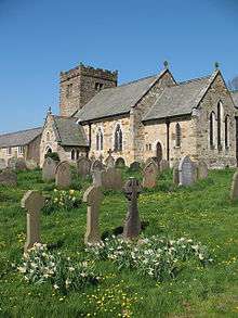
There is a church in the village dedicated to St Mary. The Grade II* listed building was erected in the early 12th century and underwent restoration in 1869.[11]
A Wesleyan chapel was built in the village in 1838.[3]
Notable people
Robert Thompson, whose trade-name was "the Mouseman", lived in the village. He manufactured furniture in English oak mainly for church use. His work is distinguished by a carving of a mouse somewhere on the piece. Examples can be seen on the wooden candlesticks in Westminster Abbey. These pieces were commissioned directly by the widow of the captain of HMS Barham as a memorial to the lost ship and her crew.[12]
References
- ↑ "Civil parish population 2011". Retrieved 2 August 2015.
- ↑ Kilburn in the Domesday Book. Retrieved 30 December 2012.
- 1 2 3 Bulmer's Topography, History and Directory (Private and Commercial) of North Yorkshire 1890. S&N Publishing. 1890. p. 726. ISBN 1-86150-299-0.
- 1 2 3 Lewis, Samuel (1848). Kilburn (St. Mary). A Topographical Dictionary of England. British History Online. pp. 667–672. Retrieved 7 March 2012.
- ↑ "Etymology". Retrieved 30 December 2012.
- 1 2 Ordnance Survey Open Viewer
- ↑ "Parish Council". Retrieved 30 December 2012.
- ↑ "2001 UK Census". Retrieved 30 December 2012.
- ↑ "Listed Buildings". Retrieved 30 December 2012.
- ↑ Photo and brief details
- ↑ ""Church of St Mary, Kilburn High and Low"". Retrieved 30 December 2012.
- ↑ Thompson Cartwright, Ian (2014). "Newsltter No 10" (PDF). Ion River. Ian Thompson Cartwright. p. 4. Retrieved 3 December 2015.
External links
![]() Media related to Kilburn, North Yorkshire at Wikimedia Commons
Media related to Kilburn, North Yorkshire at Wikimedia Commons