Kilgwrrwg
| Kilgwrrwg | |
| Welsh: Cilgwrrwg | |
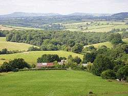 View of rolling countryside at Kilgwrrwg, looking northwards |
|
 Kilgwrrwg |
|
| OS grid reference | ST462985 |
|---|---|
| Principal area | Monmouthshire |
| Ceremonial county | Gwent |
| Country | Wales |
| Sovereign state | United Kingdom |
| Post town | CHEPSTOW |
| Postcode district | NP16 |
| Dialling code | 01291 |
| Police | Gwent |
| Fire | South Wales |
| Ambulance | Welsh |
| EU Parliament | Wales |
| UK Parliament | Monmouth |
|
|
Coordinates: 51°40′49″N 2°46′08″W / 51.680278°N 2.768889°W
Kilgwrrwg (Welsh: Cilgwrrwg) is a rural parish in Monmouthshire, south east Wales, United Kingdom. It is located 7 miles (11 km) north west of Chepstow and 7 miles (11 km) south east of Usk in a network of country lanes running through the rolling hills below the Trellech ridge.[1]
History
The Welsh placename element cil means a corner, or retreat, usually in a religious context, and the settlement name is suggestive of its Celtic Christian origins.[2] In 1811 the parish had a population of 133, and in 1831 it had a population of 113 and 26 houses.[3][4][5] Historically the parish was part of the Hundred of Raglan and was endowed by the Diocese of Llandaff.[4]
Church of the Holy Cross
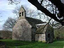
The Church of the Holy Cross at Kilgwrrwg is one of the most remote parish churches in the UK still in regular use.[6] It can only be reached by crossing two fields and a stream from the nearest house.
The church is surrounded by a partly curved churchyard, suggesting a Celtic foundation, and has been described as "the most perfect example of an early Christian site".[2] It is thought to have been referred to indirectly in a charter of about 722, cited in the Book of Llandaff.[2] According to local legend, the location of the church was determined when a pair of heifers, yoked together, were left to wander, and came to rest on a small mound, signifying that the place was divinely ordained for a church to be built there.[6]
The churchyard contains a plain short-armed stone cross, impossible to date accurately but thought by some to be pre-Norman[2] and described by others as mediaeval.[7] There is also a stone carving of a head, again thought to be pre-Norman and sometimes described as a female fertility figure,[6] placed in the wall.[2] The church is built of Old Red Sandstone. It contains some Early English architectural features, including the walls and a window in the nave.[7]
By the early nineteenth century, the building was partly ruined and used as a livestock shelter.[6] According to the local schoolteacher and philanthropist James Davies of Devauden,[8]
"...the little church was in decay; rain and snow penetrated through the roof into the body of the building, and a neighbouring farmer folded his sheep within the walls of God's house. On twelve Sundays in the year, and on those only, was public worship performed in that church; and on those occasions the accumulated filth of sheep and cattle was shovelled out the day before."
Davies encouraged the local residents to pay for the re-roofing of the church.[8] It was further restored by John Prichard around 1871, and a porch, bellcote and windows were added at that time.[7][9] Further restoration work was carried out in 1989/90.[7] It is a Grade II* listed building.[10]
Other buildings
Kilgwrrwg House is a hall house of the early sixteenth century, with a massive chimney stack of later date. The house is of architectural and historical interest.[11]
The small hamlet of Kilgwrrwg Common is located about one mile from the church. Great Kilgwrrwg Farm is also located in the vicinity.[12]
References
- ↑ Botanical Society of the British Isles (1902). Report for 1879-1947. p. 357. Retrieved 17 April 2012.
- 1 2 3 4 5 Zaluckyj, Sarah; Zaluckyj, John (2006). The Celtic Christian Sites of the Central and Southern Marches. Hereford: Logaston Press. pp. 333–334. ISBN 1-904396-57-7.
- ↑ Philipps, Thomas (1852). The life of James Davies, a village schoolmaster. Parker and son. p. 30. Retrieved 17 April 2012.
- 1 2 Lewis, Samuel (1831). A Topographical Dictionary of England. Lewis. p. 504. Retrieved 17 April 2012.
- ↑ Moule, Thomas (1837). The English Counties Delineated. Virtue. p. 58. Retrieved 17 April 2012.
- 1 2 3 4 Aslet, Clive (15 August 2011). Villages of Britain: The Five Hundred Villages that Made the Countryside. Bloomsbury. p. 480. ISBN 978-1-4088-1799-5. Retrieved 17 April 2012.
- 1 2 3 4 Newman, John (2000). The Buildings of Wales: Gwent/Monmouthshire. Penguin Books. p. 262. ISBN 0-14-071053-1.
- 1 2 The great and good; illustrated in six sketches, Anon., 1855
- ↑ "Some East Gwent Churches". Churchcrawler. Retrieved 17 April 2012.
- ↑ "Church of the Holy Cross, Devauden". British Listed Buildings. Retrieved 17 April 2012.
- ↑
- ↑ The Municipal year book and public services directory. Municipal Publications Ltd. 1972. p. 1504. Retrieved 17 April 2012.