King Street (Alexandria, Virginia)
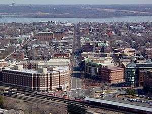
King Street is a major road in Alexandria, Virginia, United States and historic Old Town Alexandria. It extends westward from the Potomac River waterfront near the Torpedo Factory Art Center and nearby bustling tourist gift shops and restaurants, passing City Hall and the Alexandria General District Court.[1]
On reaching the Washington Metro and Amtrak stations and the George Washington National Masonic Memorial, King Street bends. Between Russell Road and Janney's Lane, green bike lanes exist. Wealthier residents fought against these.[2] King Street passes Chinquapin Recreation Center, T.C. Williams High School and several historic churches, becoming Leesburg Pike as it leaves Alexandria near the Bailey's Crossroads area. King Street becomes State Route 7 west of Washington Street (State Route 400). In Old Town Alexandria, King Street is designated as the dividing line between north and south in the addressing system, while Duke Street (State Route 236) is designated as the dividing line in the West End area of Alexandria.
The line of King Street follows the original southwest border for the District of Columbia, becoming the Leesburg Pike as it extends westward into Fairfax County. The border is close to the edge of King Street between Seminary Road and just before George Mason Drive. Route 7 then follows in close proximity the continuation of the original District border that now forms the southern edge of Arlington County, Virginia, until Seven Corners, where it enters the City of Falls Church, Virginia.
The Washington Metro has a station at King Street, just west of Old Town, on the Blue and Yellow Lines. Also, the King Street Trolley takes passengers on a ride along King Street every 15 minutes.[3]
King Street has been listed by the American Planning Association as a “2011 Great Place in America” within the “Great Streets” category.[4]
King Street is currently seen as an active strip of commerce and tourism that successfully accommodates both Alexandria’s local residents as well as its visitors. Historically the street was used as access to the seaport and later as a main center of trade. The balance between past and present is noticeable with the vitality of the street’s noteworthy character. Architectural and demolition regulations have been employed to allow for the continued visual appeal of 18th and 19th century buildings. Zoning laws, particularly those established in 2005 and 2007, are responsible for ensuring mixed use on this street. Various businesses, outdoor dining and other activities can be found all along King Street. One amenity to this street is the Market Square found at Alexandria City Hall as it is one of the oldest U.S farmers markets and is often used to provide venue space for concerts, festivals, and community events. Other features found on King Street include Alexandria City Hall, which is in the style of the period during the Second Empire, and clock tower that was designed by Benjamin Henry Latrobe. The Torpedo Factory Art Center is another hotspot for tourism and is currently used as studio housing for artists.
References
- ↑ Elise H. Ford (26 October 2010). Frommer's Washington, D.C. 2011. Frommer's. pp. 298–. ISBN 978-0-470-63004-4. Retrieved 6 June 2011.
- ↑ "King Street Bike Lane Battle Heats Up In Alexandria".
- ↑ "DASH:King Street Trolley".
- ↑ "King Street Alexandria, Virginia". Great Places in America. American Planning Association.