Kings Ripton
| Kings Ripton | |
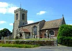 St Peter's, Kings Ripton |
|
 Kings Ripton |
|
| Population | 222 (2011) |
|---|---|
| OS grid reference | TL260765 |
| Civil parish | Kings Ripton |
| District | Huntingdonshire |
| Shire county | Cambridgeshire |
| Region | East |
| Country | England |
| Sovereign state | United Kingdom |
| Post town | HUNTINGDON |
| Postcode district | PE28 2 |
| Dialling code | 01487 |
| Police | Cambridgeshire |
| Fire | Cambridgeshire |
| Ambulance | East of England |
| EU Parliament | East of England |
|
|
Coordinates: 52°22′N 0°09′W / 52.37°N 0.15°W
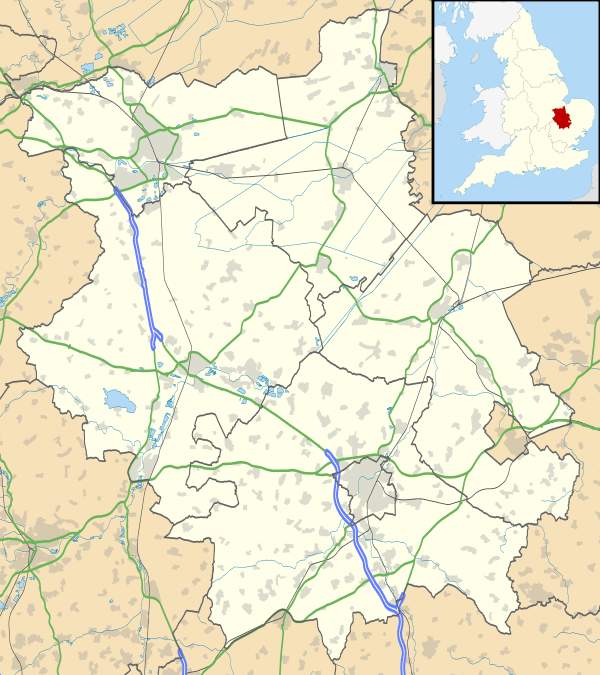
Kings Ripton (traditionally King's Ripton) is a village and civil parish in Cambridgeshire, England.[1] Kings Ripton lies approximately 3 miles (5 km) north-east of Huntingdon. Kings Ripton is situated within Huntingdonshire which is a non-metropolitan district of Cambridgeshire as well as being a historic county of England.
History
Forming part of the parish of neighbouring Hartford at the time of the Domesday Book, in a suit of 1276 the king claimed the area as the demesne of the Crown and was known for a while as Ripton Regis, a hamlet of Hartford. The prefix "King's" is used to distinguish it from neighbouring Abbots Ripton, which was at one time owned by Ramsey Abbey. The manor is currently owned by Magdalene College, Cambridge.[2]
The early Quaker leader James Nayler was buried on 21 October 1660 "in Thomas Parnell's burying-ground at King's Ripton."[3] According to the village's website "There is also a Quakers Burial ground to the rear of 'Quakers Rest' on Ramsey Road."[4]
Government
As a civil parish, Kings Ripton has a parish council. The parish council is elected by the residents of the parish who have registered on the electoral roll; the parish council is the lowest tier of government in England. A parish council is responsible for providing and maintaining a variety of local services including allotments and a cemetery; grass cutting and tree planting within public open spaces such as a village green or playing fields. The parish council reviews all planning applications that might affect the parish and makes recommendations to Huntingdonshire District Council, which is the local planning authority for the parish. The parish council also represents the views of the parish on issues such as local transport, policing and the environment. The parish council raises its own tax to pay for these services, known as the parish precept, which is collected as part of the Council Tax. The parish council is composed of five councillors and has a parish clerk. The parish council normally meets on a Tuesday in the village hall.[5]
The second tier of local government is Huntingdonshire District Council which is a non-metropolitan district of Cambridgeshire and has its headquarters in Huntingdon. Huntingdonshire District Council has 52 councillors representing 29 district wards.[6] Huntingdonshire District Council collects the council tax, and provides services such as building regulations, local planning, environmental health, leisure and tourism.[7] Kings Ripton is a part of the district ward of Upwood and The Raveleys and is represented on the district council by one councillor.[8][6] District councillors serve for four-year terms following elections to Huntingdonshire District Council.
For Kings Ripton the highest tier of local government is Cambridgeshire County Council which has administration buildings in Cambridge. The county council provides county-wide services such as major road infrastructure, fire and rescue, education, social services, libraries and heritage services.[9] Cambridgeshire County Council consists of 69 councillors representing 60 electoral divisions.[10] Kings Ripton is part of the electoral division of Warboys and Upwood[8] and is represented on the county council by one councillor.[10]
At Westminster Kings Ripton is in the parliamentary constituency of North West Cambridgeshire,[8] and elects one Member of Parliament (MP) by the first past the post system of election. Kings Ripton is represented in the House of Commons by Shailesh Vara (Conservative). Shailesh Vara has represented the constituency since 2005. The previous member of parliament was Brian Mawhinney (Conservative) who represented the constituency between 1997 and 2005. For the European Parliament Kings Ripton is part of the East of England constituency which elects seven MEPs using the d'Hondt method of party-list proportional representation.
Demography
Population
In the period 1801 to 1901 the population of Kings Ripton was recorded every ten years by the UK census. During this time the population was in the range of 111 (the lowest was in 1901) and 284 (the highest was in 1861).[11]
From 1901, a census was taken every ten years with the exception of 1941 (due to the Second World War).
| Parish |
1911 |
1921 |
1931 |
1951 |
1961 |
1971 |
1981 |
1991 |
2001 |
2011 |
|---|---|---|---|---|---|---|---|---|---|---|
| Kings Ripton | 112 | 122 | 117 | 127 | 129 | 127 | 139 | 148 | 168 | 222 |
All population census figures from report Historic Census figures Cambridgeshire to 2011 by Cambridgeshire Insight.[11]
In 2011, the parish covered an area of 1,359 acres (550 hectares)[11] and the population density of Kings Ripton in 2011 was 104.5 persons per square mile (40.4 per square kilometre).
Church
The parish church of St Peter dates from the 13th century, with extensions over the following 300 years. There was a church on the site at the time of the Norman Conquest though no trace remains of the original building.[2]
The ornamented square font dates from the 12th century.
See also
References
- ↑ Ordnance Survey: Landranger map sheet 142 Peterborough (Market Deeping & Chatteris) (Map). Ordnance Survey. 2012. ISBN 9780319229248.
- 1 2 'Parishes: King's Ripton', A History of the County of Huntingdon. 2. Victoria County History. 1932. pp. 207–210.
- ↑ Braithwaite's Beginnings of Quakerism (1911), p. 275.
- ↑ About Kings Ripton.
- ↑ "Kings Ripton Parish Council: Councillors". www.kingsriptonpc.org.uk. Kings Ripton Parish Council. Retrieved 8 February 2016.
- 1 2 "Huntingdonshire District Council: Councillors". www.huntingdonshire.gov.uk. Huntingdonshire District Council. Retrieved 23 February 2016.
- ↑ "Huntingdonshire District Council". www.huntingdonshire.gov.uk. Huntingdonshire District Council. Retrieved 23 February 2016.
- 1 2 3 "Ordnance Survey Election Maps". www.ordnancesurvey.co.uk. Ordnance Survey. Retrieved 23 February 2016.
- ↑ "Cambridgeshire County Council". www.cambridgeshire.gov.uk. Cambridgeshire County Council. Retrieved 23 February 2016.
- 1 2 "Cambridgeshire County Council: Councillors". www.cambridgeshire.gov.uk. Cambridgeshire County Council. Retrieved 15 February 2016.
- 1 2 3 "Historic Census figures Cambridgeshire to 2011" (xlsx – download). www.cambridgeshireinsight.org.uk. Cambridgeshire Insight. Retrieved 12 February 2016.
External links
| Wikimedia Commons has media related to Kings Ripton. |