Knajka
| Knajka | |
|---|---|
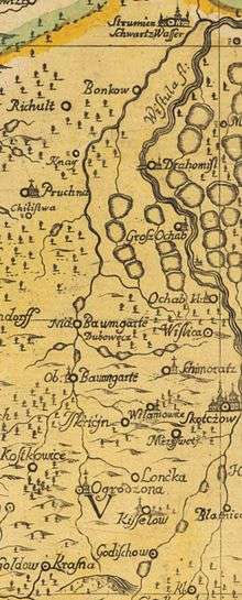 Knajka on a map from 1724 | |
| Country | Poland |
| Basin | |
| Main source |
Chełm Hill, Silesian Foothills[1] 354 m (1,161 ft)[1] |
| River mouth | Vistula |
| Basin size | 68.6 km2 (26.5 sq mi)[2] |
| Physical characteristics | |
| Length | 17 km (11 mi)[1][3] or 19 km (12 mi)[2] |
Knajka is a stream in the Cieszyn County, Silesian Voivodeship, Poland, in the historical region of Cieszyn Silesia. It is a left tributary of the Vistula, which it enters just south of Strumień. Its length is either 17 kilometres (11 mi)[1] or 19 kilometres (12 mi).[2] It flows through Ogrodzona, Kostkowice, Dębowiec, Knaj and Bąków. Numerous fish ponds are located alongside of it.
The name of the river is derived from a word knieja denoting a wild, dense forest.[4]
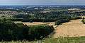 Headwaters area
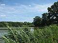 One of the fish ponds alongside the stream, in Dębowiec
Notes
- 1 2 3 4 Chwastek, Eugeniusz (May–June 2005). "Co z tą Knajką" (PDF). Dębowieści. 3 (55): 9. ISSN 1641-5477. Retrieved 2011-01-15.
- 1 2 3 "Plan Zagospodarowania Przestrzennego Województwa Śląskiego" (PDF) (in Polish). 2004. Retrieved 2011-01-13.
- ↑ Mróz, Henryk (1997). "Środowisko geograficzne polskiego Śląska Cieszyńskiego". Śląsk Cieszyński. Środowisko naturalne. Cieszyn: Macierz Ziemi Cieszyńskiej. p. 24. ISBN 83-903589-9-9.
- ↑ Mrózek, Robert (1984). Nazwy miejscowe dawnego Śląska Cieszyńskiego [Local names of former Cieszyn Silesia] (in Polish). Katowice: Uniwersytet Śląski w Katowicach. p. 91. ISSN 0208-6336.
References
- Chwastek, Eugeniusz (May–June 2005). "Co z tą Knajką" (PDF). Dębowieści. 3 (55): 9. ISSN 1641-5477. Retrieved 2011-01-15.
Coordinates: 49°52′01″N 18°43′41″E / 49.86694°N 18.72806°E
This article is issued from Wikipedia - version of the 6/19/2016. The text is available under the Creative Commons Attribution/Share Alike but additional terms may apply for the media files.