Koboro Station
Koboro Station 小幌駅 | |
|---|---|
 | |
| Location |
Toyoura, Abuta, Hokkaido Japan |
| Operated by | JR Hokkaido |
| Line(s) | Muroran Main Line |
| Other information | |
| Station code | H45 |
| History | |
| Opened | 1943 |
Koboro Station (小幌駅 Koboro-eki) is a railway station in Toyoura, Hokkaido, Japan, operated by the Hokkaido Railway Company (JR Hokkaido).
Lines
Koboro Station is served by the Muroran Main Line.
Station layout
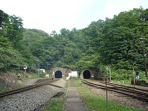
The station has two side platforms, serving one track each. The station is located between two long tunnels.
Adjacent stations
| « | Service | » | ||
|---|---|---|---|---|
| Muroran Main Line | ||||
| Shizukari | Local | Rebun | ||
History
The station opened on September 30, 1943 as Koboro Yard (Koboro shingōjō). Despite its classification as shingōjō, it accepted passengers use. The classification was changed on October 1, 1967 to Koboro Provisional Stop (Koboro kari-jōkōjō). It was given the status of full station and named Koboro Station on April 1, 1987 when JR Hokkaido was established. However, the location of the station was not officially defined by the distance for the purpose of fare calculation until March 10, 1990.[1]
In August 2015, it was announced that JR Hokkaido planned to close the station in autumn 2015, possibly as early as the end of October,[2] but in September 2015, it was revealed that JR Hokkaido was in discussion with the local government to keep the station open.[3]
Surrounding area
This station is surrounded by only a steep cliff and the sea, making this station one of the most secluded in Japan.[2]
References
- ↑ Ishino, Tetsu et al. (eds.) (1998). 停車場変遷大事典 国鉄・JR編 [Station Transition Directory - JNR/JR] (in Japanese). II. Tokyo: JTB Corporation. p. 849. ISBN 4533029809.
- 1 2 Hibino, Yoko (15 August 2015). "Railway buffs bid farewell to lonely Hokkaido station that opened in 1943". The Asahi Shimbun. Retrieved 15 August 2015.
- ↑ 八雲・鷲ノ巣、安平・東追分、根室・花咲 JR、3駅廃止を伝達 小幌駅は存続へ協議 [JR announces closure of 3 stations (Washinosu in Yakumo, Higashi-Oiwake in Abira, Hanasaki in Nemuro) - Discussions to keep Koboro Station open]. Doshin Web (in Japanese). Japan: The Hokkaido Shimbun Press. Retrieved 2 September 2015.
Coordinates: 42°35′23″N 140°32′15″E / 42.58972°N 140.53750°E