Kogu, Biu
| Kogu | |
|---|---|
| village | |
 Kogu | |
| Coordinates: 10°25′06″N 11°56′55″E / 10.41833°N 11.94861°ECoordinates: 10°25′06″N 11°56′55″E / 10.41833°N 11.94861°E | |
| Country |
|
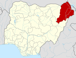
| State | Borno State |
| LGA | Biu |
| Elevation | 344 m (1,128 ft) |
| Time zone | WAT (UTC+1) |
Kogu[1] is a large village in Biu LGA, of southwestern Borno State, in northeastern Nigeria. Kogu is located on a tributary of the Yangari River about 34 kilometres (21 mi) southwest of the town of Biu.[2]
Mari Watirwa, the 20th Emir of Biu, established his capital at Kogu about 1795, after he drove the Fulani out of Biu.[3][4] In 1838, his grandson, Emir Mari Biya, moved the capital to the town of Biu.[3]
Notes
- ↑ Kogu (Approved) at GEOnet Names Server, United States National Geospatial-Intelligence Agency
- ↑ Nigeria topographic map, Series 1501 Air, NC-32-08 Gombe, Nigeria, Joint Operations Graphic (JOG) 1:250000 Scale, U.S. Army Map Service, 1967
- 1 2 Montgomery-Massingberd, Hugh (1980) "Biu" Burke's Royal Families of the World: Africa & the Middle East (Volume 2 of Burke's royal families of the world) Burke's Peerage, London, page 177, ISBN 0-85011-023-8
- ↑ Davies, J. G. (1954) The Biu book: a collation and reference book on Biu Division (Northern Nigeria) Norla, Zaria, Nigeria, page 38, OCLC 603775900
External links
- "Kogu Map — Satellite Images of Kogu" Maplandia World Gazetteer
 | ||
This article is issued from Wikipedia - version of the 12/11/2013. The text is available under the Creative Commons Attribution/Share Alike but additional terms may apply for the media files.