Krapkowice
| Krapkowice | |||
|---|---|---|---|
|
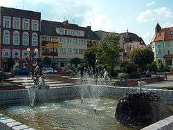
Market square | |||
| |||
 Krapkowice | |||
| Coordinates: 50°28′N 17°58′E / 50.467°N 17.967°E | |||
| Country |
| ||
| Voivodeship | Opole | ||
| County | Krapkowice County | ||
| Gmina | Gmina Krapkowice | ||
| Government | |||
| • Mayor | Piotr Solloch | ||
| Area | |||
| • Total | 20.91 km2 (8.07 sq mi) | ||
| Population (2007) | |||
| • Total | 17,840 | ||
| • Density | 850/km2 (2,200/sq mi) | ||
| Time zone | CET (UTC+1) | ||
| • Summer (DST) | CEST (UTC+2) | ||
| Postal code | 47-300 and 47-303 for Otmęt district | ||
| Car plates | OKR | ||
| Website | http://www.krapkowice.pl | ||
Krapkowice [krapkɔˈvʲit͡sɛ] (German: Krappitz) is a town in south-western Poland with 17,840 inhabitants (2007), situated in the Opole Voivodeship, straddling both banks of the Oder River at the point where it joins with the Osobłoga. It is the regional capital of Krapkowice County.
Traditionally this Upper Silesian town was a centre for leather, paper and cement manufacturing. Today only the paper and leather industries remain.
People
- Erich Abraham (1921-1943)
- Wilhelm Alexander Freund (1833-1917)[1]
- Ottomar Rosenbach
- Krzysztof Zwoliński
External links
- Official town webpage
- KRAPKOWICE.net - Portal of Krapkowice County (Polish)
- KRAPKOWICE.NET.PL - Krapkowicki Weekly (Polish)
- Jewish Community in Krapkowice on Virtual Shtetl
References
Coordinates: 50°29′N 17°58′E / 50.483°N 17.967°E
This article is issued from Wikipedia - version of the 7/11/2016. The text is available under the Creative Commons Attribution/Share Alike but additional terms may apply for the media files.

.svg.png)
