Krimmler Ache
 | |
| Location | Salzburg, |
|---|---|
| Source | At Krimmler Törl 47°06′01″N 12°16′20″E / 47.10028°N 12.27222°ECoordinates: 47°06′01″N 12°16′20″E / 47.10028°N 12.27222°E |
| Source height | ca. 2,100 m (AA) |
| Mouth | Into the Vorderkrimml into the Salzach 47°14′13″N 12°11′54″E / 47.236806°N 12.19833°E |
| Mouth height | ca. 905 m (AA) |
| Descent | ca. 1,195 m |
| Basin | Salzach/Inn/Danube/Black Sea |
| Right tributaries | Rainbach, Windbach |
| Villages | Krimml |
| Krimml Waterfalls | |
The Krimmler Ache is right tributary of the River Salzach in the Pinzgau region of the Austrian state of Salzburg. Its valley (the Krimmler Achental) forms the boundary between the Zillertal Alps in the west and the Venediger Group in the east, which belong to the High Tauern.
The valley begins above the village of Krimml at the Krimml Waterfalls and runs up to its head at the Krimmlerkees on the mountain of Dreiherrenspitze (3,499 m (AA)). The Krimmler Ache river rises at a height of about 2,500 metres, at Krimmler Törl (2,787 m (AA)) to the valley of the Obersulzbach that lies to the east.
In the upper east corner of the Krimmler Ache is the Warnsdorfer Hut and in the central section of the valley is the Krimmler Tauernhaus.
The valley of the Rainbach begins west of the Krimmler Tauernhaus, running from the Reichenspitze (3,303 m (AA)) and Rainbachspitze (3,129 m (AA)), and, near the Äußerer Unlaßalm, is the start of the Windbach valley. Both valleys run southwest into the Zillertal Alps.
 Head of the valley and the Krimmler Kees
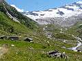 Inner Keesalm and Krimmler Kees
External links
![]() Media related to Krimmler Ache at Wikimedia Commons
Media related to Krimmler Ache at Wikimedia Commons