Kropstädt
| Kropstädt | |
|---|---|
| Stadtteil of Wittenberg | |
 | |
 Kropstädt | |
| Coordinates: 51°58′N 12°44′E / 51.967°N 12.733°ECoordinates: 51°58′N 12°44′E / 51.967°N 12.733°E | |
| Country | Germany |
| State | Saxony-Anhalt |
| District | Wittenberg |
| Town | Wittenberg |
| Area | |
| • Total | 32.13 km2 (12.41 sq mi) |
| Population (2006-12-31) | |
| • Total | 1,315 |
| • Density | 41/km2 (110/sq mi) |
| Time zone | CET/CEST (UTC+1/+2) |
| Postal codes | 06895 |
| Dialling codes | 034920 |
| Vehicle registration | WB |
Kropstädt is a village and a former municipality in Wittenberg district in Saxony-Anhalt, Germany. Since 1 January 2010, it is part of the town Wittenberg.
Geography
Kropstädt lies about 12 km northeast of Lutherstadt Wittenberg in the Fläming and is part of the Fläming Nature Park, which was opened in 2005.
Economy and transportation
Federal Highway (Bundesstraße) B 2 from Wittenberg to Berlin runs right through the community.
Sights
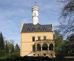
- Castle Kropstädt with garden, built around 1850 on the place of the former water castle Liesnitz, which was built in 1150.
Personalities
- Hans-Eckardt Wenzel, born 31 July 1955 is a German singer-songwriter, musician and lyricist.
| Wikimedia Commons has media related to Fläming Nature Park. |
This article is issued from Wikipedia - version of the 6/22/2015. The text is available under the Creative Commons Attribution/Share Alike but additional terms may apply for the media files.